|
|
|
|
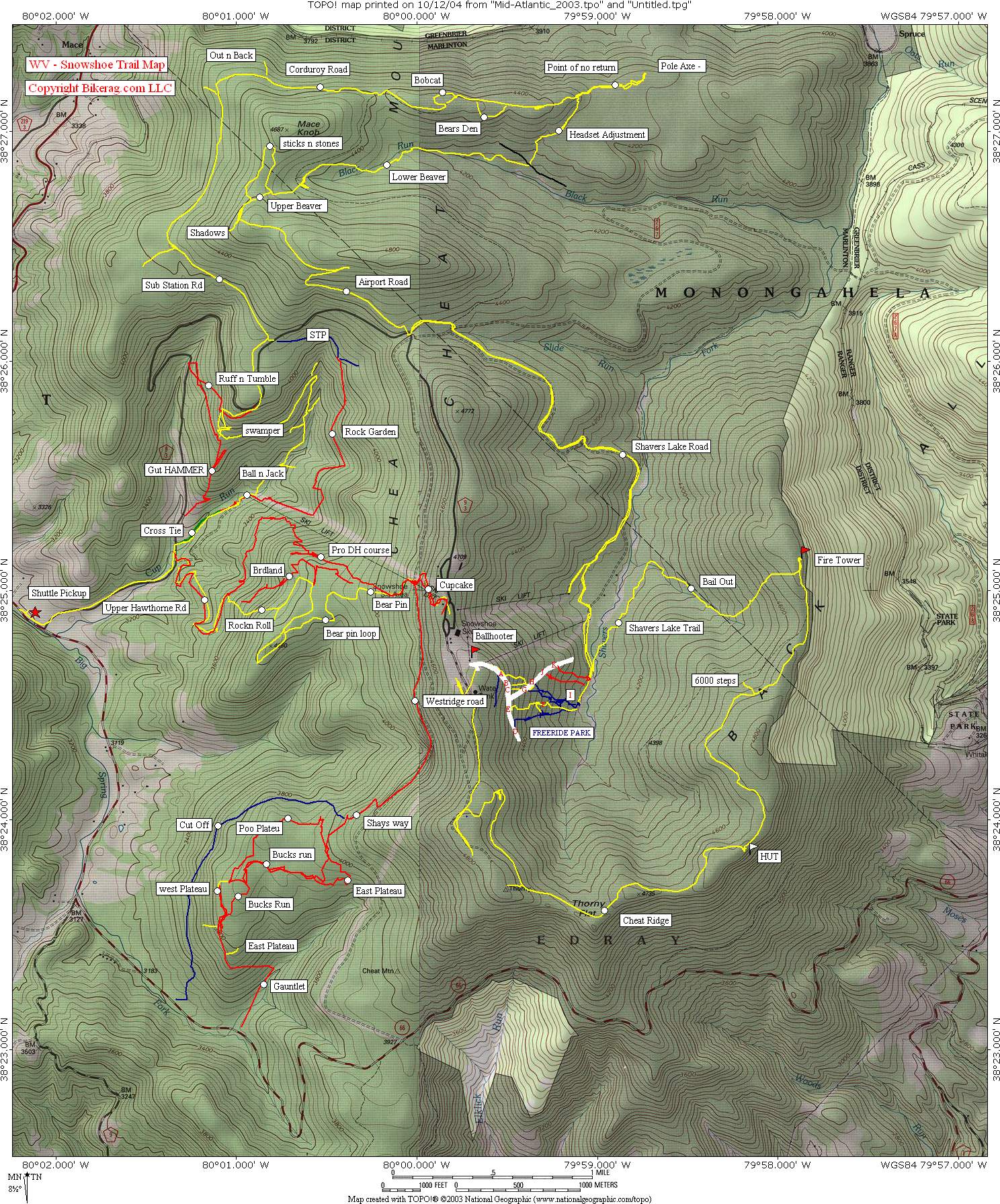
| Topo Trail Map Get a park map, there free, but not error free. |
Map Legend | Rag DH & XC Pictures |


|
|
|
|
| Topo Trail Map Get a park map, there free, but not error free. |
Map Legend | Rag DH & XC Pictures |
|
WV - Snowshoe Mountain Resort - Mountain Bike Trail Review with Map and Pictures |
|||||||||||||||||||||||||||||||||||||||||||||||||||||||||||||||||||||||||||||
Directions - route 79 south to Weston
WV, 33 east to Elkins, then 250/219, Huttonsville take a right on 219 south
take a left on 66, another left at mountain entrance, go uphill for about 6
miles and your on top of the world.. |
Description - Snowshoe is a full service resort with shuttle service, lift service on some weekends, free ride park (check mountain for closing times), DH trails and XC trails not to mention the 24 hour race, and a plethora of hotels and restaurants.. The trails.. Shay Way - intermediate singletrack that exists on a double track grass road, pretty fast and straight, not too steep. Poo Plateau, West Plateau, East Plateau, Bucks Run - Great XC type single track with some good rock sections, some logs, few small log jumps, couple log pyramids. You can ride all this stuff during one shuttle run, dont worry there is hardly any uphilling.. The Gauntlet - slightly overated rocky doubletrack, little steep, little rocky, fun, just not gonzo, insane like everyone rants about. To Granma's house - Nice single track instead of road, what a contracept, couple rock sections to keep you on your twinkle toes. Cupcake - sleezy double, but youll cross the pro DH course and be tempted to crack your helmet on it like Hot Lips did.. Pro DH course was pretty cool DH run, and was actually dry when we rode it.. Some nice lines, well marked. On your way down the pro DH if your over your head, look for Bear Pin on the left roped off - Take Bear Pin - Really nice buff xc loop, very scenic, some techs, flat.. Rock-N-Roll - starts nice.. single rocky down, gets steeper and wider similar to the gauntlet. Bandsaw - was pretty mild beginner run, go up go down. Cat Tracks - no longer exists, try to find it and youll be pulling an SMR pedalling all the way up to the condo's.. Cut Off - Bad trail, like props run, but no fun, wettest trail yet, waste of a shuttle. Birdland - awesome.. starts as cool single track, very scenic, then gets wider and rockier, one nice 3 foot rock jump. Rock Garden - like the name says - welcome to the bone yard.. wide trail with big loose rocks, fun as hell, very techy and runs into lower part of Ball N The Jack which is good. Ruff n Tumble - Steep drop in, then buff single AND THEN tightish loose rocky boney to switchback, slight uphill. Gut Hammer - Not too exciting, starts as single, then fall line wide down, not too rocky. Cross Tie - great trail, singletrack, rocky Beginner ?? Dont think so, short but sweet. Cheat Mountain Ridge trail - BULLDOZED in spots, soft mushy, but rideable. 6000 Steps - partially bulldozed, avoid that climb.. Bail Out - Not on biking map, awesome downhill from fire tower, its your only good option.. Mcdonald Way & Pole Axe - bad mushy trails says HLM. Airport Runway - Just a fireroad, slight tech near switchback, nice view, its a get you there trail. Upper Beaver Dam - awesome fun technical trail down, add in Sticks N Stones for more miles. Lower Beaver Dam - when its dry as a bone there will be mud holes, strange trail, some great flow, mudd with gravel, many bridges, part of the 24 hour course. A Headset Adjustment - Note, trail not shown correctly on map, from Lower Beaver Dam, take right, then look for it on left, the straight trail is abandoned, decent trail, but needed clearing. Point of No Return - wicked cool trail but short, some nice technical manuevers, crazy dark green moss forest, really cool, take it to Pole Axe and do a U-turn.. Enchanted Forest, Bobcat, Bears Den - all decent singletrack trails.. Corduroy Road - Rocky stutter bump single track, very scenic, slightly technical - its a single track, not a road!!! Swamper - uphill singletrack with some rock piles - gets you to waterfall trails and Ball Hammer.. Ball Hammer - Ok rocky DH run, but short lived and tough to get to on your DH bike (some uphilling). Free ride park trails - A, B, C, Steepest trails, no stunts but great, actually the entrance to A is a nice skinny, 6" drop to skinny.. D - K all had some stunts here and there, G had the most... Most stunts were not gonzo, pretty wide, but some very tall, moderately intimidating.. Not alot of hucks or drops, the few that were there had questionable landings, like drop to rock garden or drop to turn.. We spent about 2/3 of a day on the park side and had a blast, the trails were pretty technical by themselves.. The few trails we missed - Give us some feedback, what are they like?? The Shadows, Round About, Slide Run, Upper ball & Jack, Powder Puff, Free DH ride L,M,N,O,.. Imbalicous, Bobcat Alley, Highwall, Chain Grabber, Turkey Trot, Take it Easy, Thorny Flats.. Loops - We did a pretty sweet XC loop - here it is - Cheat Ridge to fire tower, U-turn, 50 feet, take right on Bail Out (some hike a bike), left on Shavers Lake Trail going around lake, right on Shavers Lake Road, follow up to Airport Runway, Upper Beaver Dam, to Sticks N Stones, back to Upper Beaver Dam, to Lower Beaver Dam (trail head up Black Run Road on right a few feet), to A Headset Adjustment, right on Point of No Return, till you get to Pole Axe, do a U-turn, double back and ride to Encahnted Forest, Bobcat, Corduroy Road, left on Sub Station Road. Option to pedal uphill or go down for one shuttle.. IF you go down, I suggest, STP to Rock Garden, to Ball N The Jack to Cross Tie.. Shuttle run XC - Cupcake to westridge road, to shay way, to poo plateau, take left, to bucks run to east plateau loop, double back on bucks run continue to gauntlet or zig zag, then at bottom take to granmas house back to shuttle.. Next lap take cupcake to short run Pro DH course, look for bear pin on left (roped off - why I dont know), take bear pin, then left on bear pin loop clockwise and birdland down to uppper hawthorne road, take right, look for trail on right after switchback, marked in blue on snowshoe bike map, road take left, another left on road back to shuttle. Pre-ride Music: |
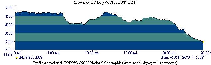
Total Miles: 75?? |
Elevation Change Feet -
2000 climbing on bike + shuttle from bottom back
to top |
|
Disclaimer: Caution - Use this map at your
own risk. Bikerag.com and affiliates will not accept
responsibility for an personal injury, property damage or trespassing while
using this map. Trail users shall obey all signs, and always obtain
permission from the land owner to use trails for any sporting activity.
Permission to use trails should not be assumed. This map simply
contains topographical information and trails that existed at one time.
Trails shown maybe be missing, not accurate, closed, overgrown etc.... |
To
view larger version of map, right click on map and select View Image. |
| ||||||||||||||||||||||||||||||||||||||||||||||||||||||||||||||||||||||