|
|
|
|
| Topo Trail Map | Map Legend | Bikerag Pictures |


|
UT - Poison spider mesa to portal loop - Mountain Bike Trail Review with Map and Pictures |
|||||||||||||||||||||||||||||||||||||||||||||||||||||||||||||||||||||||||||||
Directions - From town, cross river, take left
on potash road, go past the portal trailhead, past wallstreet the climbing
area and look for left into parking lot at dinosaur tracks sign. |
Description - From
what I heard, more sand than cape cod here, so I was avoiding it, but my
bitch destiny called again with a recent rain so I had to check it out.. My
riding life partner PMD was sick so this was to be my first solo utah ride..
Lucky for my I met up with Rod in the parking lot - Easy Easy now, this isnt
cruisy woods. So here's the ride, Starts up some switchbacks, im thunkin,
hey this isnt bad on 10 day old legs, then around turn 6.4 a wall of loose
large gravel and sand - I think boneyard and attack, barely clean it.. Keep
going up and it turns to mainly slickrock with some patches of sand. But I
have to say, the longest section I hiked was about 121 feet.. And most of
the other sand was downhill, with speed get behind seat and have fun
surfing.. Slickrock gets pretty dam steep as you go up, very rolly, up and
down.. Some techs here and there, but pretty moderate, mainlhy smoothe
slickrock, I hit a few drops, some nice tech ups and one 20 foot roller.
Take a trip to the arch, steep down where it says "arch" carved in the
stone.. Makeable up, just don't try and crawl down in the arch pit, I see
cable rub from past rescues?? Ok they say you can do a lariat if you follow
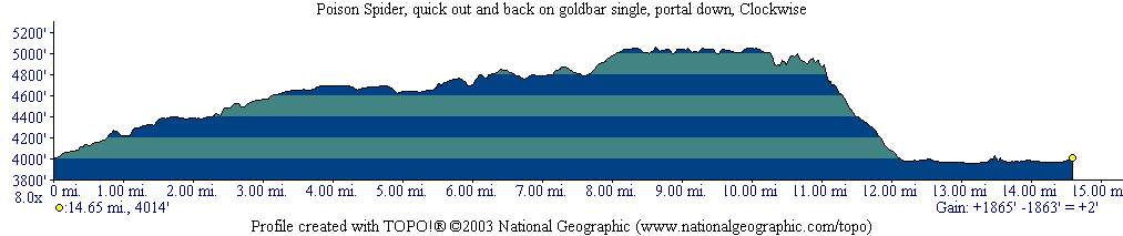
the jeep marks, but I see sand Sandy.. Loops - Out and back, loop with portal, loop with portal and extra loop on portion of golbar rim for epic ride. Pre-ride Music: |
Total Miles: loop is 14.5 miles, 1800 ft
elevation gane |
|
|
Disclaimer: Caution - Use this map at your
own risk. Bikerag.com and affiliates will not accept
responsibility for an personal injury, property damage or trespassing while
using this map. Trail users shall obey all signs, and always obtain
permission from the land owner to use trails for any sporting activity.
Permission to use trails should not be assumed. This map simply
contains topographical information and trails that existed at one time.
Trails shown maybe be missing, not accurate, closed, overgrown etc.... |
To
view larger version of map, right click on map and select View Image. |
| ||||||||||||||||||||||||||||||||||||||||||||||||||||||||||||||||||||||


