Topo Trail Map

Moab Area UT Trail Map

Map Legend Bikerag Pictures

Post a Picture and view Posted Pictures


UT - Amasa Back - Mountain Bike Trail Review with Map and Pictures

Rating Explanation (0-5)                 Category:

Overall Rating

Single-Track Adventure Climbing Free-ride Fun Fear      Trail Enhancements Scenery Technicalities
4.69 3.5 3 4 4.8 4.5 natural 4.9 4.74 4.9
GPS  Files - (Contact Bikerag To Upload Your files)
Google Earth GPX Map File GPX Routes Other
  amasaback.gpx    
       
For PERSONAL use only - Please read our GPS info page
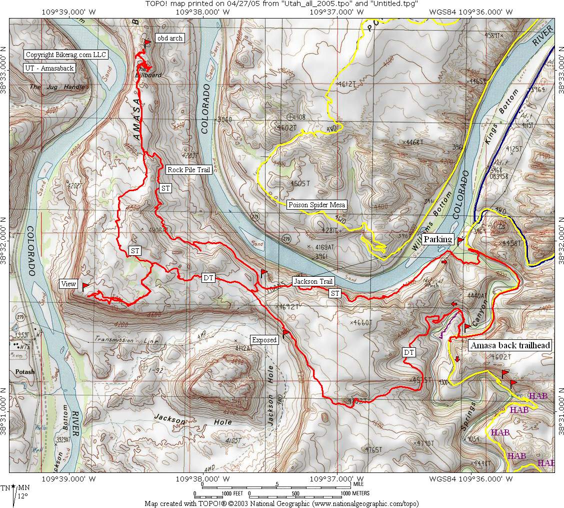
Directions - From center of town head south on 191 and take right at McDonalds on kane creek road.  Follow for about 4.71 miles and park on right after cattle guard, 2 large parking lots are available for trail users.

Description -   This ride focking rocks.. In the past the classic Amasa back ride was done as an out and back, but new singletrack has been added making the perfect loop.. I will warn you though the singletrack on the return down is very technical and very exposed in spots.. If you are an expert + rider, you'll love it.. Intermediates & beginners, will be walking several sections.

So back to the ride - starting anywhere on the loop, I suggest the parking area just past the cattle grate on Kane creek near Prichett trailhead. Travel down kane creek road ad look for the Amasa back trailhead - Cliffhanger steel sign. Go down awesome rock drops with infinite lines, hit short tech singletrack and cross the stream. The way up was pretty consistent, mainly awesome slickrock with great technical sections. One slightly exposed section as you head down past Jacobs ladder.. Keep climbing and note the pile of rocks near a turn on the way up (this is where the singletrack home begins).. Keep climbing up slickrock till you can ride no further, hangout, eat, drink and enjoy the view.. Take pictures of each other in promiscuous positions, whatever turns you on.. Now double back on slickrock and find that left on singletrack, awesome singletrack with some nice kickers, just don't pull an HH on your new 575 and end up in the bionic crust (and im not talking about the brown stuff on your tighty whiteys).. As the trail makes a 90 degree turn you can do an out and back on some really cool slickrock, just keep your crew together, look for OBD arch.. See how many riders you can fit in the arch and send me a picture, im hoping there will be some ladies with you.. Double back and get back on the singletrack, this is where the fun STARTS??!! Crazy awesome pukes in heaven singles, drops, steeps, techs, behind the seat, YES!!! Jane is the hero of the day for leading this ride (for now hint hint).. There were about 5 major sections that were a little too exposed or just sick for me, but the rest was the perfect balance of flow and treachery.. Route finding can be a bit tricky in spots so make sure you follow the rock piles, I think that's what they call the upper section, the rock pile trail.. At mid point you have a bail out at the jackass trail, this short switchback will put you back on the Amasa Back singletrack in minutes if your clicking your ruby road bike shoes to get back to dallas..

Second section of the single is the Jackson trail, truly awesome, very exposed, great moves.. Watch out for that lord of the rings tree that grabbed PMD's bar and send her OTB.. Anyway, im rambling, at the bottom, trail runs right into a stream, a deep stream.. GI's chest high line is straight, if your riding with babes in cotton and its cold out, go this way.. But if your riding with a nice digital camera take a right through the jungle (with others) and shuttle your bike along the rivers edge.. Then follow trail to wicked cool urinal wall ride, exposed, not deadly, but very commital.. Ride out and enjoy a shallower water crossing, back at car in 1 minute, I promise..
 

Loops - Ride this as a loop as described, Clockwise, up the slickrock, down the singletrack if your looking for the full on adventure.  Shorter, less technical, less exposed ride would be out and back on the slickrock.

Pre-ride Music: Keepin it Steel
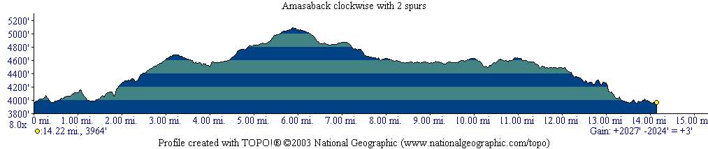
Total Miles: 14.5 :  2027 vertical feet of climbing / descending

With so many great biking locations in Utah you might find yourself looking for moving companies to help you relocate to the area before you know it. Regardless if you're ready to find a moving company to move to the area or just need that moving company to deliver your biking gear for a quick visit, this is one location that won't disappoint.

Local Bike Shops  Advertise Here !!
Lodging Temp Remove Lodging Add
Restaurants Advertise Here !!
Local Websites Advertise Here !! - Free Links may be applicable..  Just Ask..
Land Manager & other Info Contact Bikerag - To update land manager info.
Related Guide Books & Mapping Software  Mountain Bike Guide Books - Used & New

 Topo Software for all states - Used & New


Disclaimer: Caution - Use this map at your own risk.  Bikerag.com and affiliates will not accept responsibility for an personal injury, property damage or trespassing while using this map.  Trail users shall obey all signs, and always obtain permission from the land owner to use trails for any sporting activity.  Permission to use trails should not be assumed.  This map simply contains topographical information and trails that existed at one time.  Trails shown maybe be missing, not accurate, closed, overgrown etc....
 To view larger version of map, right click on map and select View Image.


Copyright by Bikerag.com, LLC.  All rights reserved.