|
|
|
|
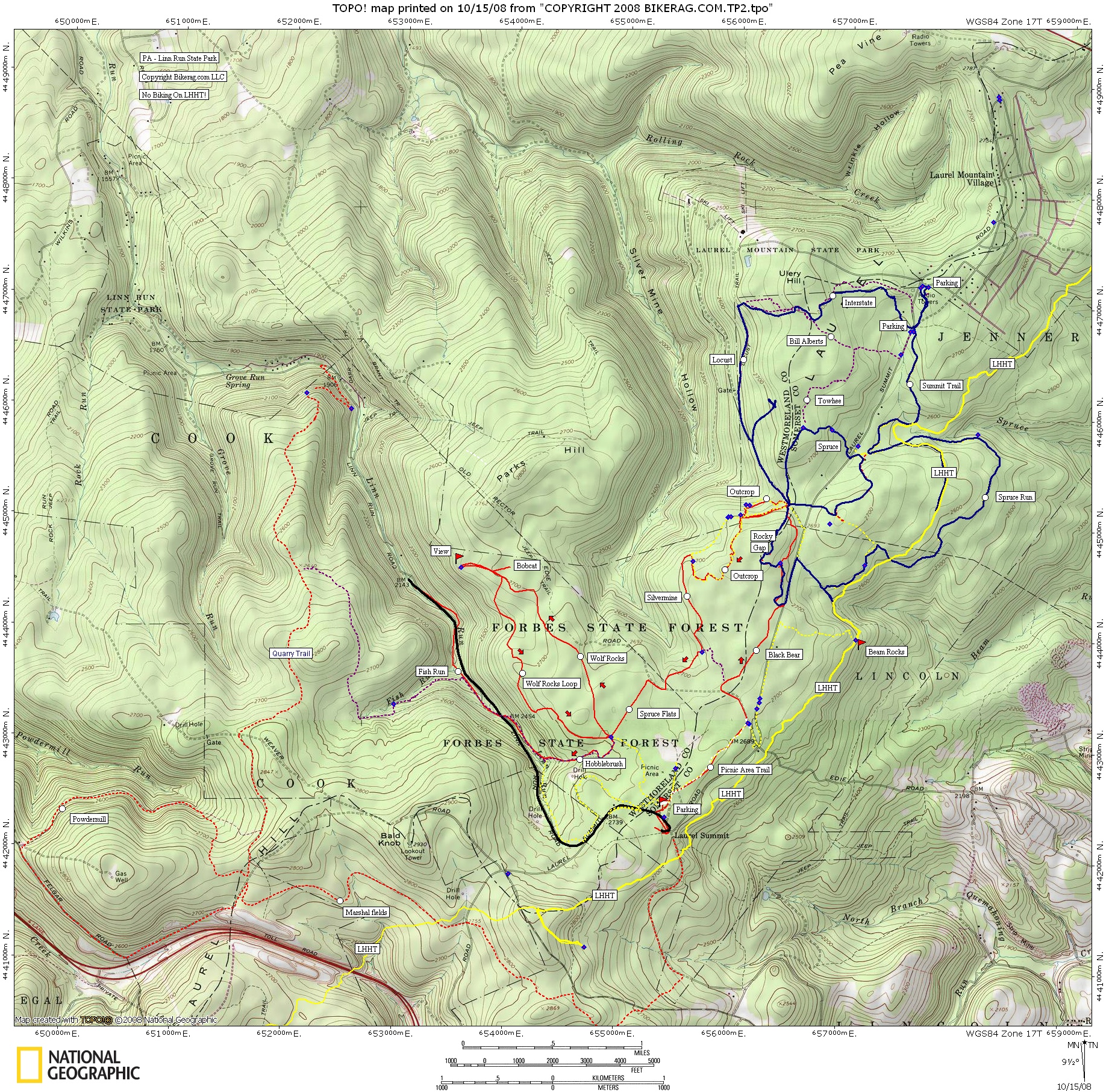
| Laurel Mountain Trail Map | Map Legend |


|
PA - Laurel Mountain - Linn Run State Park - (Forbes State Forest) Mountain Bike Trail Review with Map and Pictures - |
||||||||||||||||||||||||||||||||||||||||||||||||||||
|
||||||||||||||||||||||||||||||||||||||||||||||||||||
| Directions - From Route 30, take Laurel summit
road (highest point on route 30) and park at the Laurel summit parking lot.
Update 2008 - Liked this area so much from we decided to go back. It just rained a bit so we decided to hit all of the trails we missed last time, which were a little more intermediate. Hit summit trail to spruce run to black bear to rocky gap (awesome trail), back on another section of spruce to locust back home.. Rocky gap was the coolest trail we hit this time, some nice rocky technical lines, few log rides, one really cool rock corridor that was too wet and slimy to ride. Watch out for the LHHT hiking trail, its REAL easy to end up on it as its not marked that well, but its blazed YELLOW so make sure and stay off it. No bikes. I would skip Locust camp road to Bill alberts, it was marked expert on the map I have, but was just FR tp grassy double! All in all another great ride, lots of miles in here, amazing scenery. Description - This ride is the most fun you can have in one day in PA.. I Contorted the Expert route outlined on Cyclesa.com and basically removed the beginner/ intermediate loop near 30. What a purfect cross stuntery loop. Great mix of technical trail, some log rides, some super fun natural rock lines, whole bunch of moderate drops under 3 feet.. Some good ups, some killer rock gardens.. And its pretty flat with the exception of Fish Run which ended with pretty long road ride back up to the car.. Stop reading my drabble - Ride here.. This place rocks, not one bad thing to say.. Technical Mayhem, natural lines everywhere.. Loops - (14 miles) From lot at laurel summit, take warm-up on picnic area trail, left on road, right on black bear, end of black bear take left on road, slight uphill look for OUtcrop on RIGHT, follow outcrop basically back to where you were at end of bear, go back up road, and then take a LEFT on outcrop, to left on silvermine at field (no sign by the way, if the hills are alive, with the sound of music, take a freakin left), follow silvermine, bear right and follow road, look for left on spruce flats (recently widened?), right on wolf rocks trail, all the way out to view, then back on wolf rocks LOOP (very rocky, techy, cleanable), back to where you were, right on Hobblebrush, little bushwacky but good singletrack, to fish run crosses road many times, then ends, climb back up the road to the car.. See http://www.cyclesa.com For more loops & decent maps. |
||||||||||||||||||||||||||||||||||||||||||||||||||||
| Pre-ride Music: | ||||||||||||||||||||||||||||||||||||||||||||||||||||
| Total Miles: 25+ | ||||||||||||||||||||||||||||||||||||||||||||||||||||
| Elevation Change Feet - Our 14.3 mile loop had 850 vertical.. | ||||||||||||||||||||||||||||||||||||||||||||||||||||
|
||||||||||||||||||||||||||||||||||||||||||||||||||||
| Disclaimer: Caution - Use this map at your own risk. Bikerag.com and affiliates will not accept responsibility for an personal injury, property damage or trespassing while using this map. Trail users shall obey all signs, and always obtain permission from the land owner to use trails for any sporting activity. Permission to use trails should not be assumed. This map simply contains topographical information and trails that existed at one time. Trails shown maybe be missing, not accurate, closed, overgrown etc.... | ||||||||||||||||||||||||||||||||||||||||||||||||||||
| To
view larger version of map, right click on map and select View Image.
|
||||||||||||||||||||||||||||||||||||||||||||||||||||