|
|
|
|
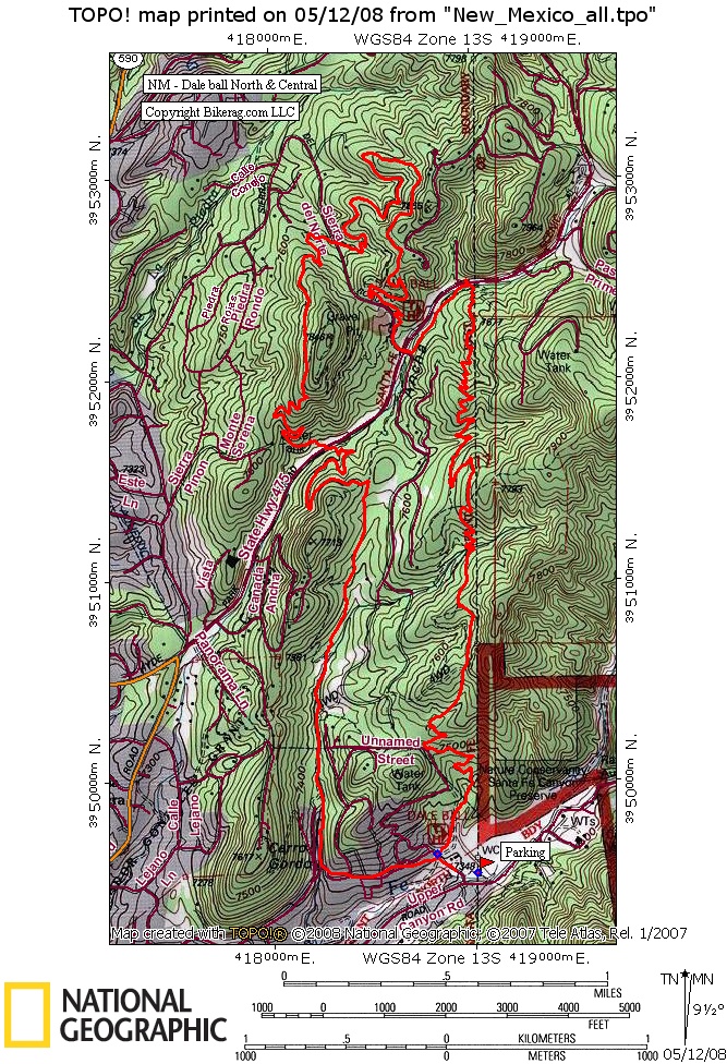
| Trail map Great online map & brochure of dale ball with numbered intersections. |
Map Legend |


| Dale Ball North & Central Trail system - Santa Fe, New Mexico - Mountain Bike Trail Review with Map and Pictures | ||||||||||||||||||||||||||||||||||||||||||||||||||||
|
||||||||||||||||||||||||||||||||||||||||||||||||||||
| Directions - (see brochure for trailhead
location) - Basically from downtown santa fe, head east, get on canyon road
(the road with all the art galleries, after you pass the galleries the
trailhead will be on your left. Description - First of all, although its always nice to have a map in your pocket, this trail system has a map at every single intersection! We did a nice 10 mile clockwise loop that hit most of the trails in dale ball north and central. The trails on the left side of the loop were 99% buff singletrack that were so dam pretty it looks like they were landscaped by a professional. The only technical aspect was a few switchbacks, but the trail was laid out very nicely and had some great flow to it, not to mention some neat views. The right side of the loop was a little more interesting with a few rock areas, but still 90% buff. For us this was a great day for a rest ride Loops - 29-28-27-24-20-19-11-10-7-6-5-4-3-long way to 2- 1-9-13-14-15-16-22 right turn to 23-25 left turn to 26 27-28- back home |
||||||||||||||||||||||||||||||||||||||||||||||||||||
| Pre-ride Music: | ||||||||||||||||||||||||||||||||||||||||||||||||||||
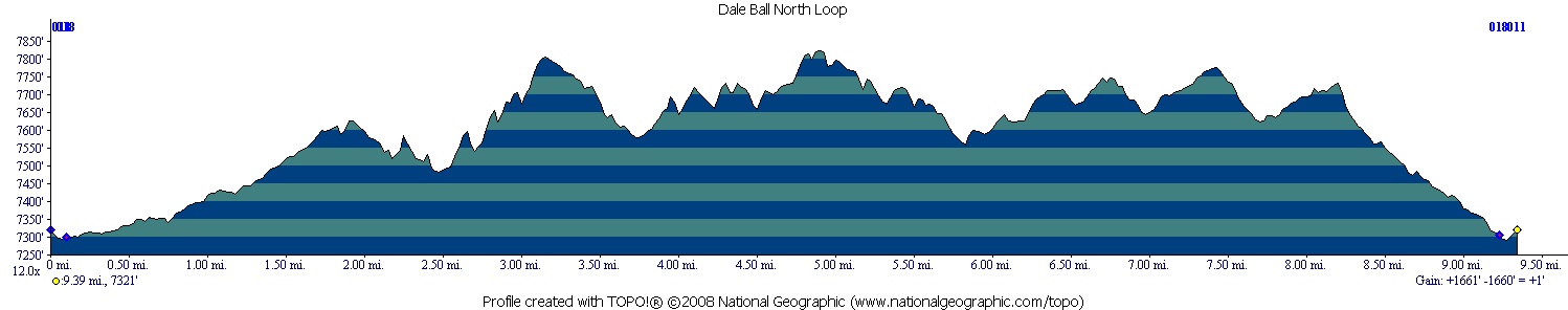
| Total Miles: 15 ish for all trails? | ||||||||||||||||||||||||||||||||||||||||||||||||||||
|
Elevation Change Feet - 1700
|
||||||||||||||||||||||||||||||||||||||||||||||||||||
|
||||||||||||||||||||||||||||||||||||||||||||||||||||
| Disclaimer: Caution - Use this map at your own risk. Bikerag.com and affiliates will not accept responsibility for an personal injury, property damage or trespassing while using this map. Trail users shall obey all signs, and always obtain permission from the land owner to use trails for any sporting activity. Permission to use trails should not be assumed. This map simply contains topographical information and trails that existed at one time. Trails shown maybe be missing, not accurate, closed, overgrown etc.... | ||||||||||||||||||||||||||||||||||||||||||||||||||||
| To
view larger version of map, right click on map and select View Image.
|
||||||||||||||||||||||||||||||||||||||||||||||||||||