|
|
|
|
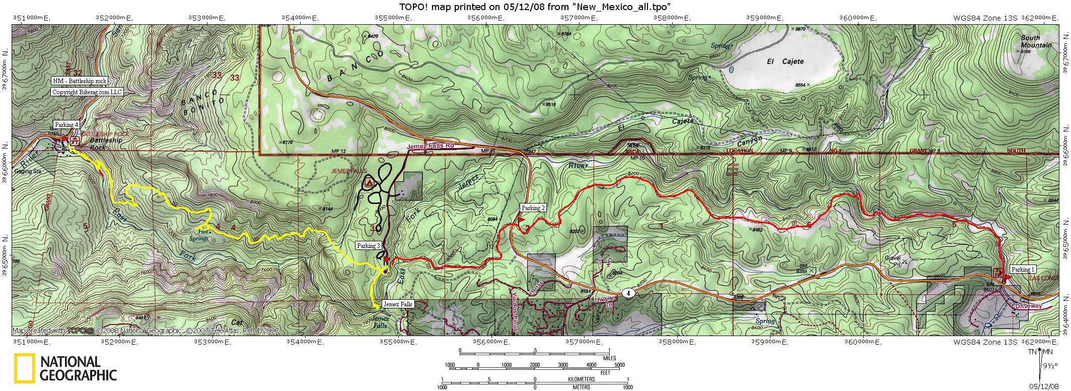
| Battleship Rock - East fork trail map | Map Legend |


|
Battlehship Rock - East Fork - Jemez - Mountain Bike Trail Review with Map and Pictures
Preliminary Review - Just one Ride |
||||||||||||||||||||||||||||||||||||||||||||||||||||
|
||||||||||||||||||||||||||||||||||||||||||||||||||||
| Directions - From Los Alamos take 501 to route
4 West. At about 12.9 miles you will pass the first parking area on
the map. I suggest you do this ride as a shuttle, drive to battleship
rock parking area (parking 4 on map), leave car, turn back and start at
Parking 1. We did this as an out an back riding between parking 3 and
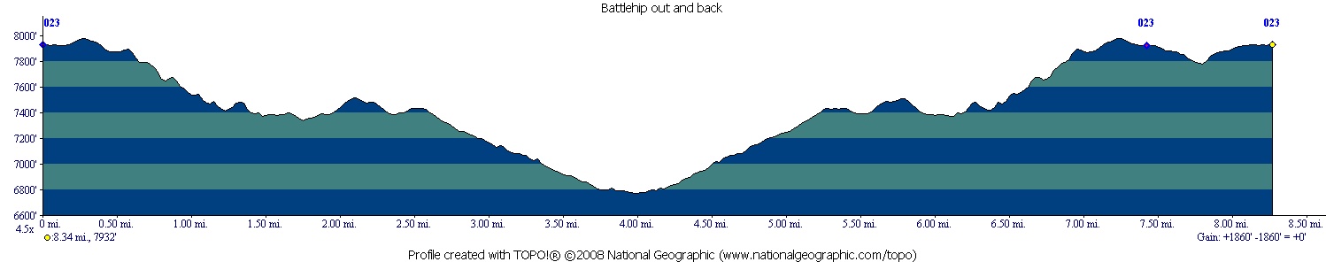
4. Description - This is a killer ride! We only rode from parking 3 to parking 4 and back roughly 8 miles total, but well worth the drive (shown yellow on map). Trail started out kind of buff with some nice small drops over water bars and roots. The trail got progressively more interesting as we rode - running into a pretty techy switchback section and many sections of tight bench cut trail with amazing views of some tent rocks. Add in a few drops, rock gardens and rollers and we have the ingredients for a primo ride. Almost everything was ride able on the way down, the route back was another story.. Im guessing about 10 hike a bikes for a good rider.. The up-hilling wasn't as brutal as I thought, it was so technical that you didn't feel like you were climbing so much (1900 vertical in 4 miles). Dont forget to check out the McCauley hot springs on your way through, you cant miss them. Actually think they are more like warm springs, but hey, still very cool. Also a trip to Jemez falls is not far off the beaten path, just a 1/4 mile pretty flat from the east fork trail at the Jemez falls parking area. Even some rocks to play on there! Loops - Its an out and back, unless you shuttle. |
||||||||||||||||||||||||||||||||||||||||||||||||||||
| Pre-ride Music: | ||||||||||||||||||||||||||||||||||||||||||||||||||||
| Total Miles: total trail is about 8 miles, so 16 miles if you ride the entire length without shuttle. | ||||||||||||||||||||||||||||||||||||||||||||||||||||
|
Elevation Change Feet - 1900 vert in the 4 miles between parking 3 & 4 !!
|
||||||||||||||||||||||||||||||||||||||||||||||||||||
|
||||||||||||||||||||||||||||||||||||||||||||||||||||
| Disclaimer: Caution - Use this map at your own risk. Bikerag.com and affiliates will not accept responsibility for an personal injury, property damage or trespassing while using this map. Trail users shall obey all signs, and always obtain permission from the land owner to use trails for any sporting activity. Permission to use trails should not be assumed. This map simply contains topographical information and trails that existed at one time. Trails shown maybe be missing, not accurate, closed, overgrown etc.... | ||||||||||||||||||||||||||||||||||||||||||||||||||||
| To
view larger version of map, right click on map and select View Image.
|
||||||||||||||||||||||||||||||||||||||||||||||||||||