|
|
|
|
| Topo Trail Map | Map Legend | Bikerag Pictures |
|
NH - Rob Brook Trail - Bear Notch Road - Mountain Bike Trail Review with Map and Pictures Preliminary Review - 75% |
|||||||||||||||||||||||||||||||||||||||||||||||||||||||||||||||||||||||||||||
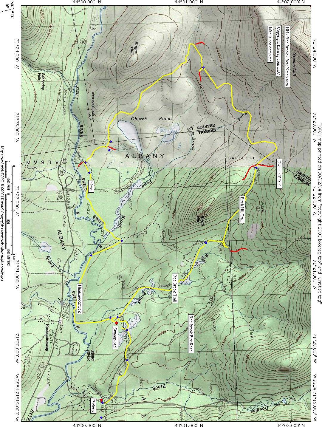
Directions - To Bear Notch Road:
From Plymouth, NH, head North on I-93, exit 32 - Lincoln, 112 East on
Kancamagus for 22.75 miles, left on Bear notch road, go .87 miles park on
left where there is a wooden sign post with what used to have a trail map of
the area. It's was up when we got there but at the end of the ride we
noticed it was ripped out from behind the plexiglass. |
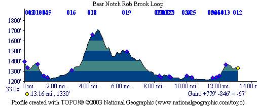
Description - This was one of the better rides we've found in northern new hampshire.. The trails range from rooty technical singletrack to fire roads.. Definitely a good variety depending on the loop you choose.. The rob brook trail was awesome, scenic, technical in parts due to minor rocks, major roots and some cool plank bridges.. Be warned though, many bridges were out when we rode there forcing you do dismount here and there.. Although its a decently well signed park, it has a backwoodsy feel, and many signs are missing as you venture further out.. The birch hill trail was basically poor mans single track - new term - or a wide grassy snowmobile trail with a singletrack cut in it.. Nanamocomuck ski trail was really cool at the start with some wild bill like plank rides, then rooty singletrack.. Major bridge was out on the way back, forcing PMD to "get wet".. Loops - From parking go through gate on Rob Brook FR, take first right onto Rob Brook Trail (awesome), after plank bridge take right to continue on Rob Brook Trail (watch out for the missing bridges). At end of RB Trail take right, look for first left onto Birch Hill Trail (not marked but uphill, wide doubletrack-if you go too far you will see a sign for Owl's Cliffs), take Rt onto Rob Brook FR, follow to sign for Nanamocomuck Ski Trail, back on Rob Brook Tr for a PHAT lariat... Pre-ride music: Gonna have a wet dream...crusing
thru the gulf stream..woohoo ..woohoo |
Total Miles : 20+ |
|
|
Disclaimer: Caution - Use this map at your
own risk. Bikerag.com and affiliates will not accept
responsibility for an personal injury, property damage or trespassing while
using this map. Trail users shall obey all signs, and always obtain
permission from the land owner to use trails for any sporting activity.
Permission to use trails should not be assumed. This map simply
contains topographical information and trails that existed at one time.
Trails shown maybe be missing, not accurate, closed, overgrown etc.... |
To
view larger version of map, right click on map and select View Image. |
| ||||||||||||||||||||||||||||||||||||||||||||||||||||||||||||||||||||||