|
|
|
|
| Topo Trail Map | Map Legend | Bikerag Pictures |
|
MA - The Fells - Middlesex Fells - Mountain Bike Trail Review with Map and Pictures |
||||||||||||||||||||||||||||||||||||||||||||||||||||
Review By Crash & Burn - thanks man |
||||||||||||||||||||||||||||||||||||||||||||||||||||
| Directions - From Boston take 93 North to
Exit 33. There are several parking lots to ride from. The best which adds a
good few miles of single track on the east side of 93 on the Cross Fells
Trail is off of elm street. Take the 1st right off of the rotary at exit 33
onto Fellsway west, then right onto elm st, about .7 miles to parking lot on
left. Or continue to follow Fellsway west until the Sheepfold parking lot
about 1 mile past elm street after you cross under 93. The Bellvue Pond lot
also links to the mtb loop and is off of South Border Rd which is another
exit off of the rotary if you follow it ¾ of the way around. This lot has
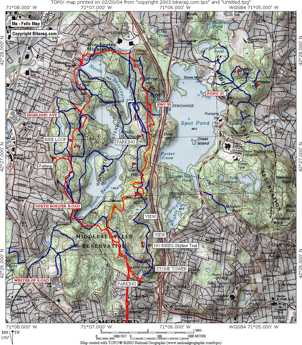
easy access to the stone tower via fire road. Description - The Fells is a great place to ride because it’s so close to the city. Its about a 7 mile ride from Boston and only a few from Cambridge or Somerville, just enough for a good warm up before you hit the trail. There is a well marked (red MTB Loop signs) 8 mile loop with a lot of ups and downs and a few good climbs. Unfortunately about 6.5 of those miles are double track or crappy single track. The truth is there are probably 20 miles of awesome singletrack with some of the most technical rock infested riding that I’ve ever ridden…uhhh….I mean hiked, because all of these trails areas are off limits to bikes. The hikers and walkers need to get there heads out of there dog’s asses and share the trails with us enthusiastic bikers willing to spend time and effort to make the park better and cleaner. Until then, its in our best interest to be courteous and stick to the loop so we don’t get banned all together because certain people would love it. Oh, there are actually a 3 natural drops all about 4 feet that make the loop rideable. And there are some awesome views of Boston along the skyline trail and from atop the stone tower, which of course is also not part of the mtb loop, but there is a fire road going up there from the parking area by Belevue Pond that gets you up there.Loops- |
||||||||||||||||||||||||||||||||||||||||||||||||||||
| Pre-ride Music: | ||||||||||||||||||||||||||||||||||||||||||||||||||||
| Total Miles: | ||||||||||||||||||||||||||||||||||||||||||||||||||||
| Elevation Change Feet - Elevation Profile | ||||||||||||||||||||||||||||||||||||||||||||||||||||
|
||||||||||||||||||||||||||||||||||||||||||||||||||||
| Disclaimer: Caution - Use this map at your own risk. Bikerag.com and affiliates will not accept responsibility for an personal injury, property damage or trespassing while using this map. Trail users shall obey all signs, and always obtain permission from the land owner to use trails for any sporting activity. Permission to use trails should not be assumed. This map simply contains topographical information and trails that existed at one time. Trails shown maybe be missing, not accurate, closed, overgrown etc.... | ||||||||||||||||||||||||||||||||||||||||||||||||||||
| To
view larger version of map, right click on map and select View Image.
|
||||||||||||||||||||||||||||||||||||||||||||||||||||