|
|
|
|
| Topo Trail Map | Map Legend | Bikerag Pictures |
|
MA - Chicopee State Park - Mountain Bike Trail Review with Map and Pictures |
|||||||||||||||||||||||||||||||||||||||||||||||||||||||||||||||||||||||||||||
Directions - From the mass turnpike (90), take
exit 6. After toll take a right, go past Dunkin Donuts, look for park
entrance on left.. There is a $5.00 fee to enter park so you may want
to park elsewhere and ride in.. |
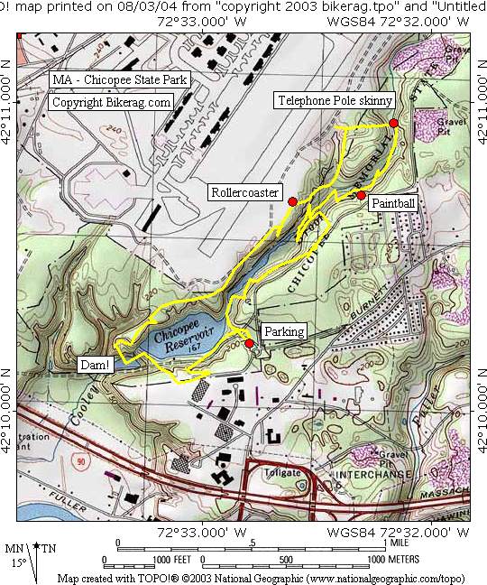
Description - My bro - Moas and I used to travel to Chicopee back in the day to get fiberglass supplies for our many wind surfboard making projects.. Now that you can get these supplies online and I have experienced the wrath of chicopee state park I would say there is no reason to go there, unless you are already there.. The trails - This park is a Tiny strip of land between Westover air force base and some roads. The typical terrain is super buff double track by the river. A very short section of singletrack exists by the beaver pond but is short lived, its technical, scenic, off camber, sweet - just need 7 more miles of it.. There is a paintball area that you may want to avoid after school gets out.. One stunt to speak of - the telephone pole skinny, you fall you die.. The rollercoaster section looked cool, but I mean, its 200 feet of trail, super buff double, fun but again short lived.. 1 hour bored me to death, not a bad place for beginners or kids messing around with bmx bikes and paint ball guns.. Pre-ride Music: |
Total Miles: 7 ish |
Elevation Change Feet - It's flat |
|
Disclaimer: Caution - Use this map at your
own risk. Bikerag.com and affiliates will not accept
responsibility for an personal injury, property damage or trespassing while
using this map. Trail users shall obey all signs, and always obtain
permission from the land owner to use trails for any sporting activity.
Permission to use trails should not be assumed. This map simply
contains topographical information and trails that existed at one time.
Trails shown maybe be missing, not accurate, closed, overgrown etc.... |
To
view larger version of map, right click on map and select View Image. |
| ||||||||||||||||||||||||||||||||||||||||||||||||||||||||||||||||||||||