|
CT - Chatfield Hollow State Park - Mountain Bike Trail Review with Map and Pictures |
|||||||||||||||||||||||||||||||||||||||||||||||||||||||||||||||||||||||||||
Directions - Take route 9 south to exit 9,
route 81 south to route 80 west, look for signs, right turn into park.. |
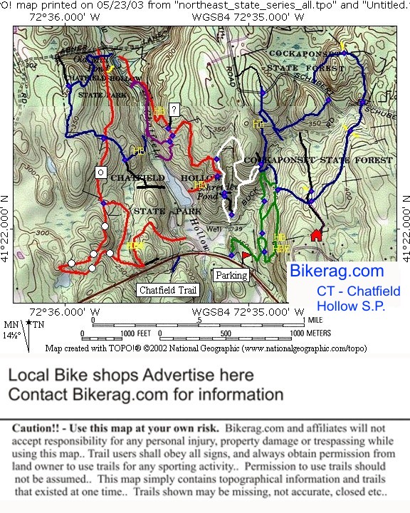
Description - Ill warn you up front, this little gem of a park is not for the timid biker.. More of a hiking spot.. Hike a bike extreme.. Don't say I didn't warn you.. Besides the hike a bike, the trails are awesome, lots of slickrock, lots of rocky trail, lots of rock gardens, switchbacks, log crossings, some drops, some rooty sections, very very very little smooth singletrack.. If your not hiking your bike, your riding on SOLID expert trails here.. A constant challenge.. Loops - It is so important to pick your route here, need to work on linking the trails and sections of trails together to avoid HAB's as much as possible.. I think I have a good 12 mile loop worked out with minimal Hike A bikes (HAB's).. Will test in DRY conditions soon and post, maybe a map by numbers.. Green (chimney Trail) = Long hike a bike up hill, some good rock gardens, hike a bike across stream.. White (Lookout Trail) = Awesome trail, only a couple short hike a bikes either way.. Lots of slickrock and techs up and down.. Red (Ridge Trail) = Good trail, but starts or finishes with epic stair climb decent.. One pretty extended hike a bike section, flat-ish but not rideable by humans.. If taken CCW you can bail on purple to avoid hike a bike.. Purple (Covered Bridge Trail) = Only like one slllllight hike a bike here, very ride-able, rocky.. Blue (west Crest) = One hike a bike, great techs, part is fire roadish, other part is nice rocky singletrack.. Orange (deep woods) = Hike a bike at the very end, may be avoided if you take unmarked trail near road, but not sure where it goes... Hike a bike extreme, not recommended.. Orange trail is great besides that, rocks, logs, skinny bridge over stream.. Orange White dot (pond trail) = Very cool trail, rocky single track, peaks over large slickrock, only one slight bike carry for 5 feet.. Blue (east woods) = Another good section, very ride-able.. Some actual semi smooth sections, but some great tech's, 1 mild hike a bike up, easily ridden down.. Cool switchback too, down only, up would be hike a bike, I think.. Blue (Chatfield Trail) = On Topo map, Hike a bikes are labeled with Yellow HB, and HBE.. HB is moderate hike a bike, short carry up, usually rideable down.. HBE is Hike A bike Extreme, Carry up or down, unless your a really good trials rider.. Local Business Sponsor
Pre-ride Music: Slip sliddin away.... |
Total Miles: 19 ish |
Elevation Change Feet - 7 miles was 1000 vert! |
|
| ||||||||||||||||||||||||||||||||||||||||||||||||||||||||||||||||||||||


