|
CT - Westwoods - Mountain Bike Trail Review with Map and Pictures |
|||||||||||||||||||||||||||||||||||||||||||||||||||||||||||||||||||||||||||
- 2007 update
- Urgent Trail use issue has been brought to my attention by the
Guilford Land Trust. |
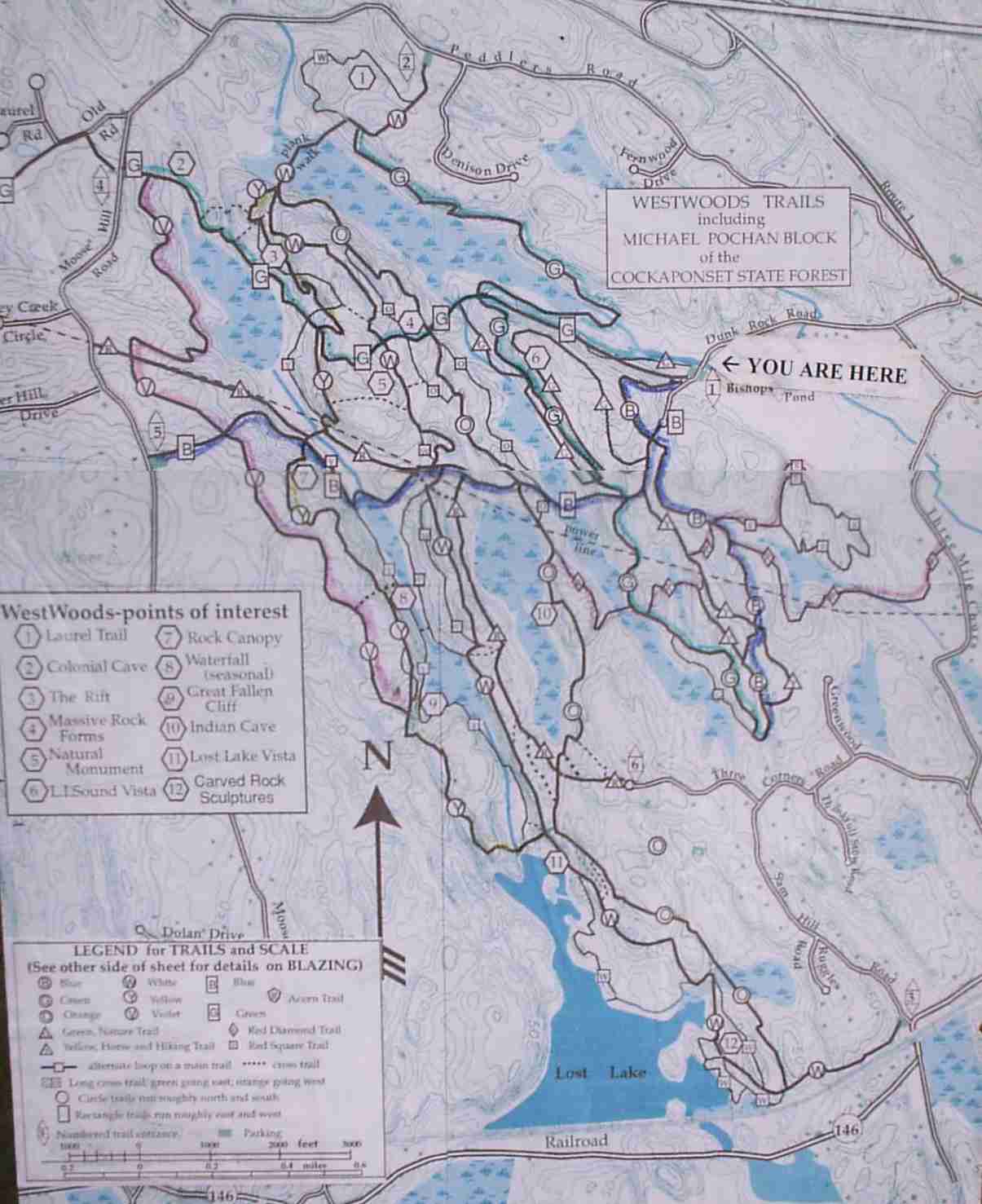
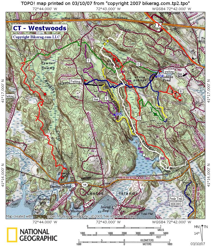
Mountain bike access has been threatened at Westwoods because of illegal trail building, widening of trails & building of jumps. If you ride here PLEASE stay on the trail, Do not build any jumps, Do not Alter any existing trails, Do not build new trails. There are plenty of natural trail features that are right on the trail at Westwoods and there are many miles of trails to explore. +++++++++++++++++++++++++++++++++++++++++++++++++++++++++++++++++++++++++++++++++++++++++++++++++++++++++++++++ Directions - From rte 95, take exit 57, travel EAST? on rte 1 (post road - towards New London) for .67 miles. Pass Bishops Orchards and take right onto Drunk Rock Road (elliptical blue trail sign). Follow road to end and park in designated area. A park trail map is posted on board for your use. Please do not park at the top of the cul-de-sac, the neighbors do not like that, ride up the road is a good warmup. There are NO Motorized vehicles allowed here. No dirt bikes. No ATV's. No automobiles. No Pickups. No heavy equipment. Description - Westwoods is just an awesome place to ride. The trails here are managed by the Guilford land conservation trust. It is located in Guilford, and is very close to the CT shoreline. The technical riding here is pretty much the best in CT, and there are TONS of trails. There are very few fire road type trails here - its mostly just rocky single-track. The trails are marked very well, but can be confusing on your first ride there.. Basically there are many colored trails that run pretty much north to south. Each colored trail may split many times between a round symbol and a square symbol. I think the round symbol usually indicates a hiking trail (or hike a bike) and a square is more ride-able. If you see a colored X on a trail that is a cross-connector trail. So if your on the white and see a trail with a red X - that will take you to the red trail.. Even some nice views in the area with a plethora of wildlife. Several bridges were built here to make your trip easier through the wet stuff, one is like 200 feet long!! Loops - Super Looper - Take the main blue trail all the way out to the purple. As you start taking the blue, there will be a major fire road fork, stay right, then when your down by the power lines fork left on singletrack.. Anyway, get to the purple and go LEFT. Follow purple to a funky 4 way intersection, your basically gonna take a U-turn on Yellow, up slickrock. Follow yellow which has a couple short hike a bikes, up slickrock party area, look for single down steep trail. Your back where youve been.. go back on blue and take right on red trail. This is just past that log ride I kept missing.. Take red past log stunt I built and go up, first intersection you will see 2 different white X trails, take the left one, once it hits the white take left. Follow white to lost lake play area, continue on white, bear left at hike a bike uphill, go past play area thats furthest south with the big roller, head back.. Think its orange.. After you go over bridge take right, follow up loose hill, where ally fell, little further take right on gravity cavity, green.. Follow green to red, and take red back to main trail. Take right on main trail back to car..
Other Places to Ride in the area:
Branford Supply Ponds,
Chatfield Hollow,
Cockaponset - south ,
Millers Pond state Park,
Rockland Preserve,
Timberland |
Pre-ride Music: Freestylers
- Drop the Boom |
Total Miles: At Least 23.1 |
Elevation Change Feet - |
Nearest Coffee, Sushi or other food:
From Dunk Rock road parking take a right back onto rt. 1 and take your first
right into the plaza. there is a Deli there with good eats... |
Nearest sushi: there is this sushi place on the way home, its in a red house right off the main road maybe rte 22, hate to be slanderous but DON'T EAT HERE.. I actually needed a bucket after eating here.. I think they should call the place Laxative house.. I went to pay the bill and the lady was in the back room putting curlers in her hair (NOT A PRETTY SIGHT).. No exxageration you would be better off eating scraps out of a burger king trash can.
|
| ||||||||||||||||||||||||||||||||||||||||||||||||||||||||||||||||||||


