|
CT - Salmon River - Mountain Bike Trail Review with Map and Pictures |
|||||||||||||||||||||||||||||||||||||||||||||||||||||||||||||||||||||||||
Directions - Rte 2 East to Exit 13
(Rte 66). Take right off exit and immediately come to traffic light. Take
left at light and proceed approx. 1 mile (or less) and will come to fork in
road. Stay right at fork and follow for approx. 2- 3 miles (+/-) and look
for Bull Hill Rd on right (as road begins to climb up a gradual hill).
Follow Bull Hill Rd for a few miles (steep uphill and winding road at first
and then flattens out through residential area). Continue on Bull Hill until
road begins steep winding downhill section. Toward bottom of hill is hair
pin turn in road where there is a gravel parking area which is where our
ride begins. |
There are NO Motorized vehicles
allowed here. No dirt bikes. No ATV's. No automobiles. No Pickups.
No heavy equipment. Description - A very scenic, cool, hilly single track ride that even has a couple stunts to play on. Starting on the railroad bed you will find some moderately technical single track to the north and south. Crossing the river over the cumstock bridge, the trail follows the river for a bit and you start to gain elevation (all ride-able!!), onward, you will find one great slick-rock-ish climb - several cool descents with many airtime drops. A mello seesaw and 3 foot drop for the free-riders. All in all a great place - Try not to get arrested by cops in bikini's like MOAS though!! This is tubeless T-shirt todd country - look out for him!! Pre-ride Music: Phish
- My friend My friend he's got a knife |
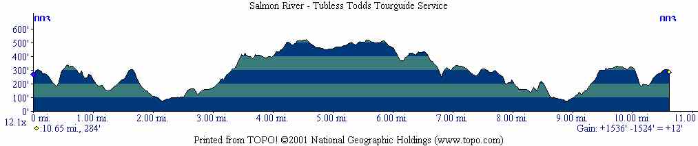
Total Miles: 25+ |
Elevation Change - 1536 Feet - Elevation
Profile |
Nearest Coffee, Sushi or other food: TT's house |
| ||||||||||||||||||||||||||||||||||||||||||||||||||||||||||||||||||||


