|
|
|
|
| Bikerag - Topo Trail Map See Also www.gjmountainbiking.com!! |
Map Legend |


|
|
|
|
| Bikerag - Topo Trail Map See Also www.gjmountainbiking.com!! |
Map Legend |
|
CO - UT - Rabbit Valley (McInnis Reservation area)- West Rim & Trail #2 - Mountain Bike Trail Review with Map and Pictures |
||||||||||||||||||||||||||||||||||||||||||||||||||||
|
||||||||||||||||||||||||||||||||||||||||||||||||||||
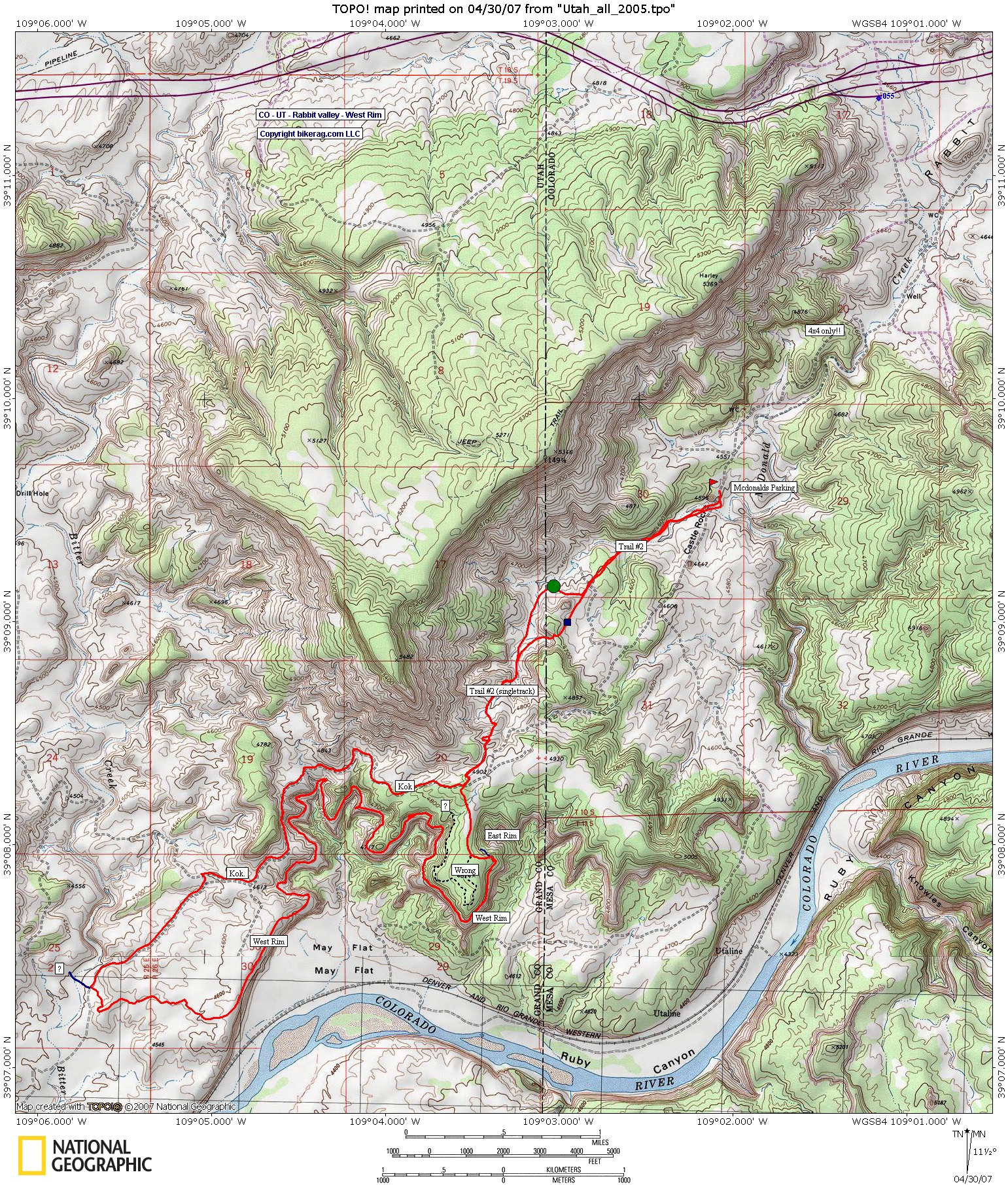
| Directions - Take I-70 to the Rabbit Valley
Exit, its right near the UT - CO border.. Conveniently located
bettween Moab and Grand junction if your traveling. I suggest parking
at the Mcdonald Trailhead that they say requires high ground clearance
Vehicle.. There are to roads that get you to the Mcdonald, the road on
your right IS FOR HIGH CLEARANCE ONLY!! Our rental SUV scrapped down
one section, but I wanted to get my $$'s worth.. If you take the left
road, you can Probably get in there with a minivan or the like but use your
own judgement. Mcdonald Parking area is 2.86 miles in, you cant miss
it, big ole pear shapped rock, adjacent a public bathroom! Description - Don't be afraid of all the moto's and ATV's in the parking lot, this is a rippin fast fun single-track ride.. There are some bits of sand here and there, but nothing to even scare PMD away. This is a Lollipop Loop. Go out on Trail #2, starts out as atv double track with some whoops, moderate climb, turns single-track, where it forks, I found the beginner side (right turn on the way out) to be more fun both ways.. Trail turns into pretty nice singletrack with just a few tech sections. At the end of the trail you hit a funny intersection with kokapelli, look for the sandy doubletrack that heads out towards the rim, on the way out there is a sandy right double that we explored first, it was ok, seemed to follow the rim, but much sandier.. So dont take that!! Keep traveling untill you start descending and turning left (towards east rim), and look for Right single-track that starts out sandy, but only for 30 feet.. Once your on the rim the trail is awesome for 7 miles, predominantly slightly downhill with short ups you can hammer down it. Some nice slickrock sections and a few technical things but mainly buff fun singletrack.. Once you get off the rim, the fun is not over, next section has some sweet flowy DH sections with some pump track whoops and jumps. Finally you intersect with fire road, take right, follow to kokapelli, take another right.. Follow Kok, back to trail #2 and surely take trail #2 back home, its 90% DH fun.. Oh yeah, amazing views from the west rim! Trail is similar to marys loop, but singletrack and mostly downill. This loop was a really good use of your earned vertical, didn't beat you down, It was an awesome ride.. Loops -Suggest you take the west rim loop CLOCKWISE |
||||||||||||||||||||||||||||||||||||||||||||||||||||
| Pre-ride Music: Deep Purple, Smoke on the water, for no reason at all, except is was playing on the way to the ride | ||||||||||||||||||||||||||||||||||||||||||||||||||||
| Total Miles: 15 | ||||||||||||||||||||||||||||||||||||||||||||||||||||
| Elevation Change Feet - 1500 vert | ||||||||||||||||||||||||||||||||||||||||||||||||||||
|
||||||||||||||||||||||||||||||||||||||||||||||||||||
| Disclaimer: Caution - Use this map at your own risk. Bikerag.com and affiliates will not accept responsibility for an personal injury, property damage or trespassing while using this map. Trail users shall obey all signs, and always obtain permission from the land owner to use trails for any sporting activity. Permission to use trails should not be assumed. This map simply contains topographical information and trails that existed at one time. Trails shown maybe be missing, not accurate, closed, overgrown etc.... | ||||||||||||||||||||||||||||||||||||||||||||||||||||
| To
view larger version of map, right click on map and select View Image.
|
||||||||||||||||||||||||||||||||||||||||||||||||||||