|
|
|
|
| Just Buy A Map Bikerag Topo - Work in progress |
Map Legend | Bikerag Pics |


|
|
|
|
| Just Buy A Map Bikerag Topo - Work in progress |
Map Legend | Bikerag Pics |
|
VT - Kingdom Trails - Burke Mountain - Mountain Bike Trail Review with Map and Pictures |
||||||||||||||||||||||||||||||||||||||||||||||||||||||||||||||||||||||||||||
This trail review is sponsored by STM. |
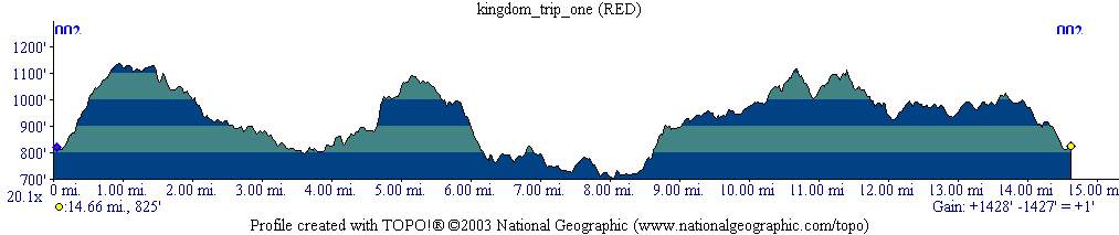
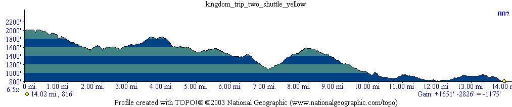
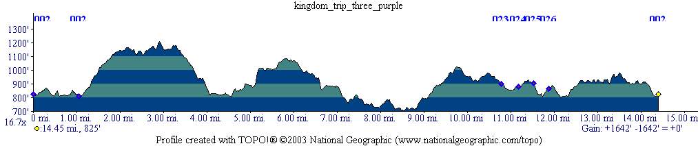
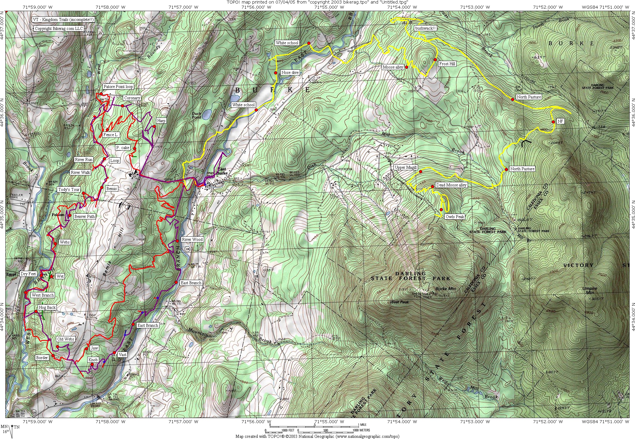
Directions - Just take 91 up to exit 24 follow signs for 114, 6 miles to east burke village.. Park at east burke sports on left, pay fee, ride.. 2011 update - Cant believe it has been so long! Did a nice 18 mile ride and we were treated to many many improvements since the last visit. Lots more berms here and there helping the flow. The Renovated Kitchel was my favorite trail for sure, jumps, berms, lots of G's, made me dizzy! Tap & die - Sidewinder awesome, great flow on all the trails. Cant wait to go back and check out the freeride additions this summer. Thumbs way up to KTA & especially to the trail builders. 2007 update - Another great ride at kingdom this weekend. Trails are naturally getting more technical as they wear in.. Riding them a little wet proved to require constant attention, riding at mach 2. Nice thing about KTA is that every time I visit new trails pop up. The coolest new trail we rode was sidewinder - Holy crap balls fun.. Super high speed roller coaster will put G-forces in your head rarely experienced on your bike.. Dam good fun. And the new climb out from sidewinder was an amazing trail with many switchbacks & nice bench cut.. Also proves to be a great location to rip with your 29'er single speed. 2005 update - Did another fine loop at kingdom. many new trails, more fun and flow. Even found a roller, a jump, 2 footer and a nice berm.. There is also talk about a DH trail opening this summer on the mountain side. See map for the 3 loops weve hit. All great 1600 vert never felt so easy. East branch trail is pretty cool with crazy huge switchback. Update 2004- Rode here again - Trails near the mountain are slightly more technical than the rest.. Dead moose, and moose alley were great.. Still not too technical, but more fun, fast, swoopy, twisty.. Couple drops here and there, 2 footer, 3 footer, roller, 8 footer, but not tons of stuff, just here and there.. Watch for new trails though!!! Hear theres a crazy free ride trail off the top?? Description - I know - your thinking what the hell is PM doing on the buffest trails in New England?? Well I just had to see what all the hype was about.. Let me tell you, for buff Single-track this is as good as it gets - just ask Jack N.... Anyway, I found the people at EBS to be very nice, they showed us a nice 20 mile loop that was actually 15 miles but who's counting?? Well they are but that's beside the point if they have 100 miles of trails or 50 miles of trails plus fire roads, the ST is good, realllll good.. It is however very important to take the trails in the right direction, the route EBS planned for us ROCKED.. Ok bad use of terminology, it kicked ass.. You know you had a good day of riding when it feels like you didn't climb and went down all day.. Well I will post the loop below... There is practically nothing technical on these trails so be warned.. Some nice FUNCTIONAL bridges, couple roots and one rock, oh and one berm I got 2 feet of air on.. Go here if you are a beginner or just like buff S-track.. I turned my free ride off and had fun, the faster you ride, the more "technical" it is.. It is good practice for twisty bike handling.. OH - lots of twists and turns - did I mention that - but not too twisty like those heinous trails at massabesic in NH.. UGHH This review was based on one ride of 15 miles - seemed to be a good sampler, so don't scold me if perhaps, I missed all the killer stuff, but let me know!!! Loops - Ok - I can't take credit for this, but this was a good loop that the EBS shop gave us and highlighted on our map... Out of shop, take a right, and another right, stay left or straight and climb East Darling hill road.. Oooo Ahhh farm scenery and tracktor hum in the background.. Right at Tee, quick left you will see trail sign onto grass path, Soon you take a right on LOOP, then left on poundcake, to fence line, to Pastore Point (intermediate), to Pastore Point Expert, thats "expert", right on coronary uphill (easy), right on loop, go PAST river run, right on bemis, right on tody's tour, left on river run, left on webs (cool!!), left on river run, right on dry feet, right on river run, right on west branch, right on meadow wood, right on border, cross road, straight, then left on jaw, left on sugar hill, left on ridge, left on vast, left on bill magill, right on bill mcgill, right on widow maker, left on pines, left on vast, left on leather wood, straight on vast, left on beat bog, right on sugarhouse run, right on kitchel, back to east darling hill road, right, left, back at bike shop... We followed this loop not missing a turn and it was 15 miles.. Pre-ride Music: |
Total Miles: |
Elevation Change Feet - Elevation
Profile |
|
To
view larger version of map, right click on map and select View Image. |
| ||||||||||||||||||||||||||||||||||||||||||||||||||||||||||||||||||||||