|
|
|
|
| Topo Trail Map | Map Legend | Bikerag Pictures |


|
|
|
|
| Topo Trail Map | Map Legend | Bikerag Pictures |
|
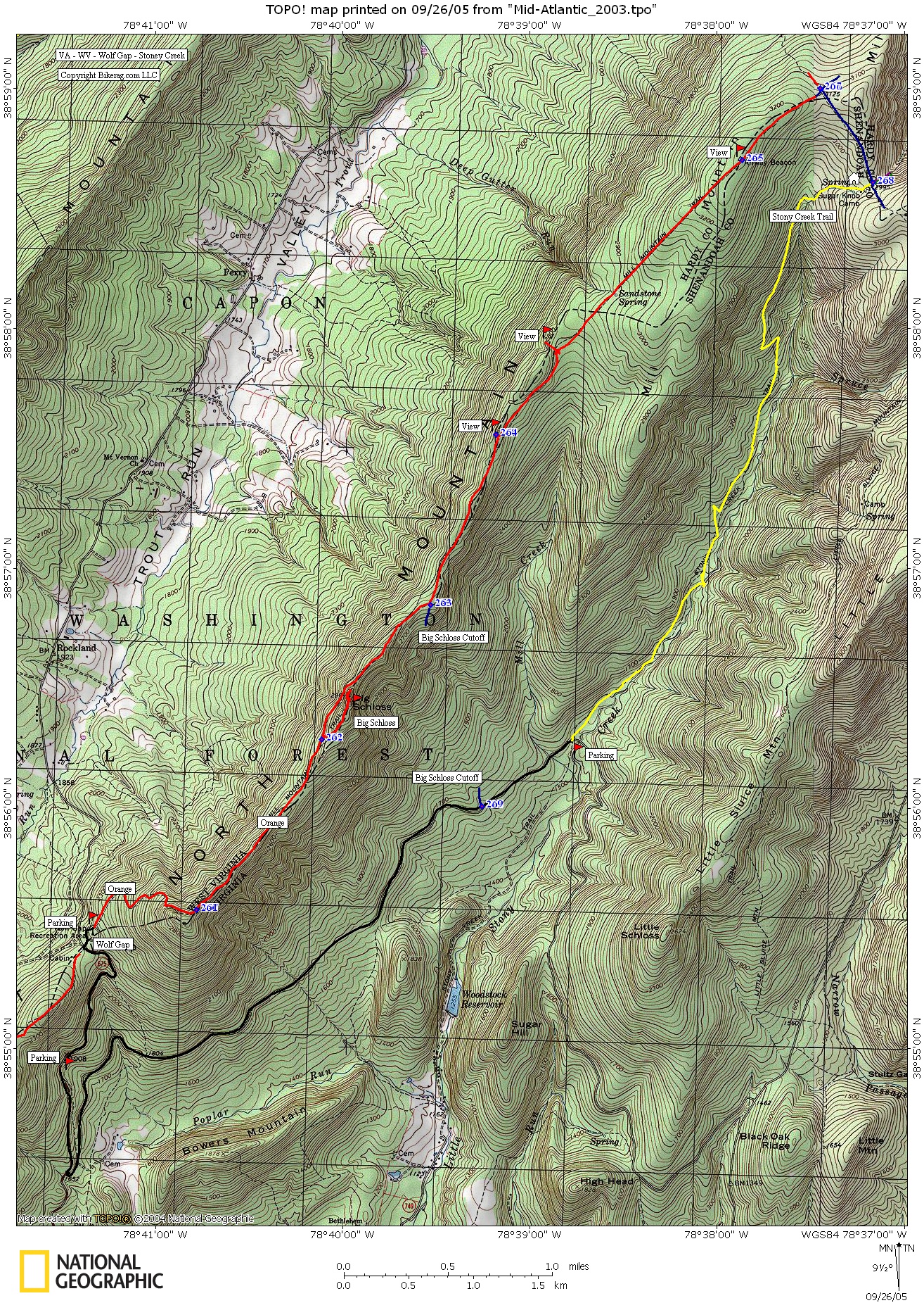
VA / WV Wolf gap - Mill mountain trail - Stony creek - Mountain Bike Trail Review with Map and Pictures |
|||||||||||||||||||||||||||||||||||||||||||||||||||||||||||||||||||||||||||||
Directions - Route 81 to exit 283. Take
42 south to columbia furnace - wolf gap road - sr 675 (funny turn - sharp right to bridge to left).
Follow past FR 92?, park on pullout or at the top in wolf gap recreation
area. You could also take a right on 92 and park at the bottom of
stony creek where there's a small parking area.
|
Description - Pictures just don't do this ride justice, you have to experience it. Thanks Tim from shenandoahbicycle for pointing this ride out. From the top, the ride starts as an innocent enough climb up double track with a few hike a bike sections that are short. Once on top the fun begins, with rocky 1.5 track right on the ridge. Sweet views and sweeter lines. Slow going embedded rock gardens, some slab, but not too too many crack baby heads. Take the out and back to big schloss.. Just a few hike a bikes up, and awesome lines down. Killer views of circling hawks and surrounding mountains from the top. Cool slabs up there too. Back down, hardest section was a triple drop, I wasn't going to hit that, saving it for the likes of GI & company, PMD talked me into it.. Good stuff. Back on orange more slow methodical lines to eat up.. Once you see big Schloss cutoff you can QM shortening your ride, but trust me its worth the longer trip.. From here the trail gets "easier" as pmd would say for a bit. Enjoy the forearm break, back in the rocks for more fun.. Couple really cool sections of slab, then long shallow uphill that's really tough to stay on, great up hilling.. Once at the top its all downhill to the uphill to the car.. Take a right at the first major intersection, then look for another right on yellow (stony creek) - 50 ft you'll see a cabin.. This trail was rippin, awesome single with root drops, rock drops, rock gardens.. Super tight lines, fun flowy, and lasts.. Lots of embedded rock, 4 miles of bliss.. Nothing gonzo, but what an incredible natural trail.. At the bottom, take a right on FR and start pedaling back towards your car.. Could be done as a shuttle but the up hilling wasn't so bad on the gravel FR and the main road. Traffic was very light on wolf gap road. Loops - Either orange to right on big schloss cutoff, back on road. Or orange to blue, to right on yellow (stony creek), back on road. Pre-ride Music: |
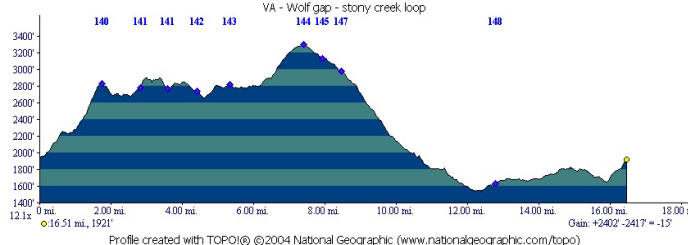
Total Miles: 16.5 |
|
|
Disclaimer: Caution - Use this map at your
own risk. Bikerag.com and affiliates will not accept
responsibility for an personal injury, property damage or trespassing while
using this map. Trail users shall obey all signs, and always obtain
permission from the land owner to use trails for any sporting activity.
Permission to use trails should not be assumed. This map simply
contains topographical information and trails that existed at one time.
Trails shown maybe be missing, not accurate, closed, overgrown etc.... |
To
view larger version of map, right click on map and select View Image. |
| ||||||||||||||||||||||||||||||||||||||||||||||||||||||||||||||||||||||