|
VA - Iron Mountain in Damascus - Mountain Bike Trail Review with Map and Pictures |
|||||||||||||||||||||||||||||||||||||||||||||||||||||||||||||||||||||||||
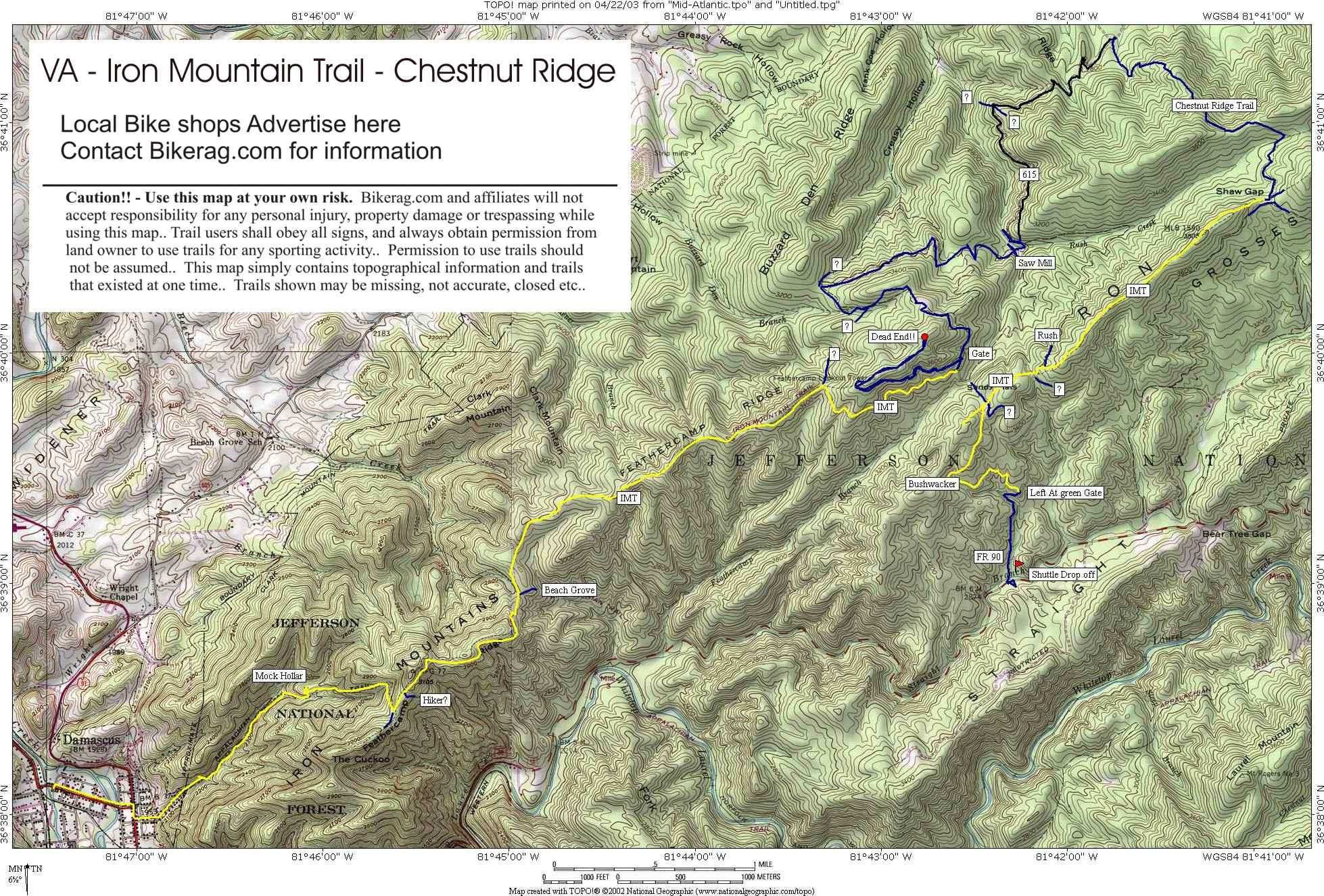
Directions - Just get to damascsus, I
suggest taking a shuttle to FR 90. Make sure and tell them you
want to go to 90 or you will end up at the creeper trail with a bunch of
hybrid bikes and tourons. |
Description - Damascus was a quaint town full of nice people who talk like Boomhower, but slower.. There are like 4 bike shuttle services in town, but DONT be fooled, they are all there to shuttle tourists up to the creeper trail where you go downhill for 17 miles, on pee gravel.. So we opted to check out the legendary Iron Mountain Trail that has received boat loads of great reviews and hype from everyone in our path.. So instead of taking the classic route described in many "best of" books - we decided to tack on a loop down chestnut ridge as many are boasting there "favorite trail".. Well the iron mountain trail is pretty much a leafy somewhat maintained wide singletrack, that is smoother than my ass on a sunday morning.. RUgged?? not sure where.. Im already so bored im thinking of other things like, what I would rather be doing with my time like sharpening forks and sticking them under my toenails, so I can coast downhill, let my feet drag and get rid of some of these leaves.... Anyway... So down the chestnut ridge trail - off camber single track, just goes straight, some gully action, some roots, very minor tech's, hey I just wasted about 1500 vertical - yipee we are at the bottom.. Time to climb gravel fire road to dirt rocky fire road.. Finally get to the "saw mill ("TRAIL")" Its a focking mushy 8 foot wide road that goes up forever, 2 miles later we hit the end and theres no indication where to go, so we burn uphill another 500 vertical to no-where dead-end.. Fine.. Turn around.. Go down pristine fourple track at 40 mph, pass the gate, find the Iron Mountain "spur" which is not a spur but does bring us to the iron mountain trail.. Down iron mountain trail gets better - still boring - buff single track that doesnt even swoop.. Off camber right then off camber left about it.. Not ONE iota of technical.. I did find one sweet 1.5 footer off a log but that was extra-cirricular anyway.. Down the mock hollow or mock hollar because youll be yelling (YO adriannnnnne!!!!) Little boney to keep you awake, one tech 2 stream crossing, power lines dangling at neck level, finally the ride is done.. There may be good trails in this area, but I doubt it - Here is the mentality.. At the hotel front desk I asked where is a good resteraunt in town.. The Lady answered "any food is good as long as im not cookin it, I mean mcdonalds is great".. Same mentality with the trails - any downhill trail is good - Bull Sheit.. \ Iron mountain was a good workout, but surely a waste of the 3000 vertical we biked, and 1000 vertical we paid to shuttle. You can do better - go to pisgah.. Pre-ride Music: Pragga
khan BOred Out of MY mind |
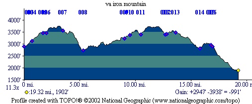
Total Miles: 20 for our loop but LOTS more
crap to adventure on |
Elevation Change Feet - Iron mountain plus
chestnut ridge was 3000 vertical with shuttle |
Nearest Coffee, Sushi or other food: Go to
town of Abingdon for good food |
|
| |||||||||||||||||||||||||||||||||||||||||||||||||||||||||||||||||||


