|
|
|
|
| Updated Map Link - Thanks Lee | Map Legend | Bikerag Pics |


|
|
|
|
| Updated Map Link - Thanks Lee | Map Legend | Bikerag Pics |
|
VA - Candlers - Mountain Bike Trail Review with Map and Pictures |
|||||||||||||||||||||||||||||||||||||||||||||||||||||||||||||||||||||||||
Directions - From 460 bypass, take Liberty
University exit, Park in one of the department store lots I guess..
Ride up candlers mountain road and take a left onto singletrack across from
the wingate hotel. |
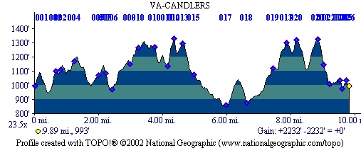
Description - First of all this is a preliminary rating, just ridden once.. You want hills for training?? Come here and ride.. Looking for pristine singletrack? Go elsewhere.. We found some nice singletrack but MAINLY fire roads and super double off camber singletrack or in lamens terms ATV rutted double track.. Some of the wider trails were fun down but not too much technical.. We did only ride 10 of the say 25 miles of trails so may have missed some good stuff for sure.. Who knows there could be secret trails hidden singletrack etc etc etc.. Ill update the review if someone tells me where the goods are.. Great views from the bald spot.. I gave 4.999 for climbing, its super steep, most vertical anywhere, great uphilling.. Loops - Not sure but I would follow someone who is local, we got semi lost with maps and GPS.. And thats rare, well were never really lost, always somewhere.. Pre-ride Music: Aerosmith
- Walk this way |
Total Miles: 25 ish?? |
Elevation Change Feet -
10 miles was 2250 feet!! |
|
|
| |||||||||||||||||||||||||||||||||||||||||||||||||||||||||||||||||||


