|
|
|
|
| Topo Trail Map See Also http://www.gjmountainbiking.com |
Map Legend |


|
Westwater Mesa - Arch Loop - Mountain Bike Trail Review with Map and Pictures Preliminary Review - Just One Ride |
||||||||||||||||||||||||||||||||||||||||||||||||||||
|
||||||||||||||||||||||||||||||||||||||||||||||||||||
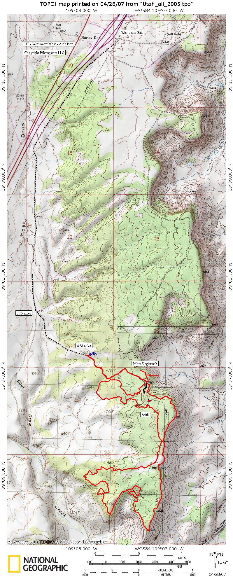
| Directions - From I-70 take the
westwater exit and head toward the Gas Pipeline Station, then take right on
paved road. Follow Paved road for like 3.55 miles and take left on
dirt road. Follow Dirt road Look for Right down hill at 4.38 miles.
You can either start here or keep driving depending on your vehicle.
There is a sign for the kokapeli right at the intersection. There were some
pull-offs here and there to park but no official parking area for the short
loop option. Description - This was a pretty cool unique ride near the UT - CO border, conveniently located between Moab and Grand Junction. Most of the trails are Moto Singletrack so conditions may change SEVERLY based on motorized traffic and weather conditions. The quality of the single-track ranges from Pristine hard pack fun tight stuff to Wider washed out beach sand.. I wasnt a huge fan of the sand sections, nor was PMD.. All in all you really dont have to walk that much, but the sand can be a little anoying. Not too much technical, some rock sections here and there, with a few drops & rollers.. There is a very cool arch you can ride - hence the arch loop name.. There are some really cool sections of trail that follow short sections of wash, and a couple lines that are just natural pump tracks. Percentage wise I would estimate 90% good trail, 10% sandy stuff. You will need to get off your bike for several very short hike a bikes throughout the loop. Pretty demanding trail, some nice flowing sections but many short steep ups. The View from the Rim is amazing, definetely a worthy ride, only downer the sand in parts. There were also some nice single-track views of the LaSalle's. Another bonus in this loop was a good fill of wildlife! I have never seen so many bunnies of course we are near Rabbit Valley. Lots of Lizards, Birds, Butterflies 7 stuff too. Loops - GI - Jane recommended taking the loop Counter Clockwise, after riding it, I agree 300%.. 11 mile loop option is a pretty good bang for your buck ride, the whole 19 miles might just ruin you. OF course I have ridden 9 days straight so don't listen to me. |
||||||||||||||||||||||||||||||||||||||||||||||||||||
| Pre-ride Music: Something by the beach boys mixed with metallica | ||||||||||||||||||||||||||||||||||||||||||||||||||||
| Total Miles: About 19 miles for the whole loop (lariat or lollipop) - Bikerag map shows a shorter version 11 mile loop | ||||||||||||||||||||||||||||||||||||||||||||||||||||
| Elevation Change Feet - 11 mile loop was 1200 feet of climbing. | ||||||||||||||||||||||||||||||||||||||||||||||||||||
|
||||||||||||||||||||||||||||||||||||||||||||||||||||
| Disclaimer: Caution - Use this map at your own risk. Bikerag.com and affiliates will not accept responsibility for an personal injury, property damage or trespassing while using this map. Trail users shall obey all signs, and always obtain permission from the land owner to use trails for any sporting activity. Permission to use trails should not be assumed. This map simply contains topographical information and trails that existed at one time. Trails shown maybe be missing, not accurate, closed, overgrown etc.... | ||||||||||||||||||||||||||||||||||||||||||||||||||||
| To
view larger version of map, right click on map and select View Image.
|
||||||||||||||||||||||||||||||||||||||||||||||||||||