|
|
|
|
| Topo Trail Map | Map Legend |


|
UT - Eagles Perch - Little canyonrim Mountain Bike Trail Review with Map and Pictures |
||||||||||||||||||||||||||||||||||||||||||||||||||||
|
||||||||||||||||||||||||||||||||||||||||||||||||||||
| Directions - This trail is pretty remote,
there are a few options on how to ride it. You can ride it from the
lower Gemini lot as a lolipop, Ride it from the upper gemini shuttle dropoff,
Do a super loop shuttle and ride From Gemini upper lot, to eagles perch to
goldbar to Portal (28 miles 2800 vertical), or last but not least, drive
your vehicle in and park somewhere near the loop, maybe at the gemini -
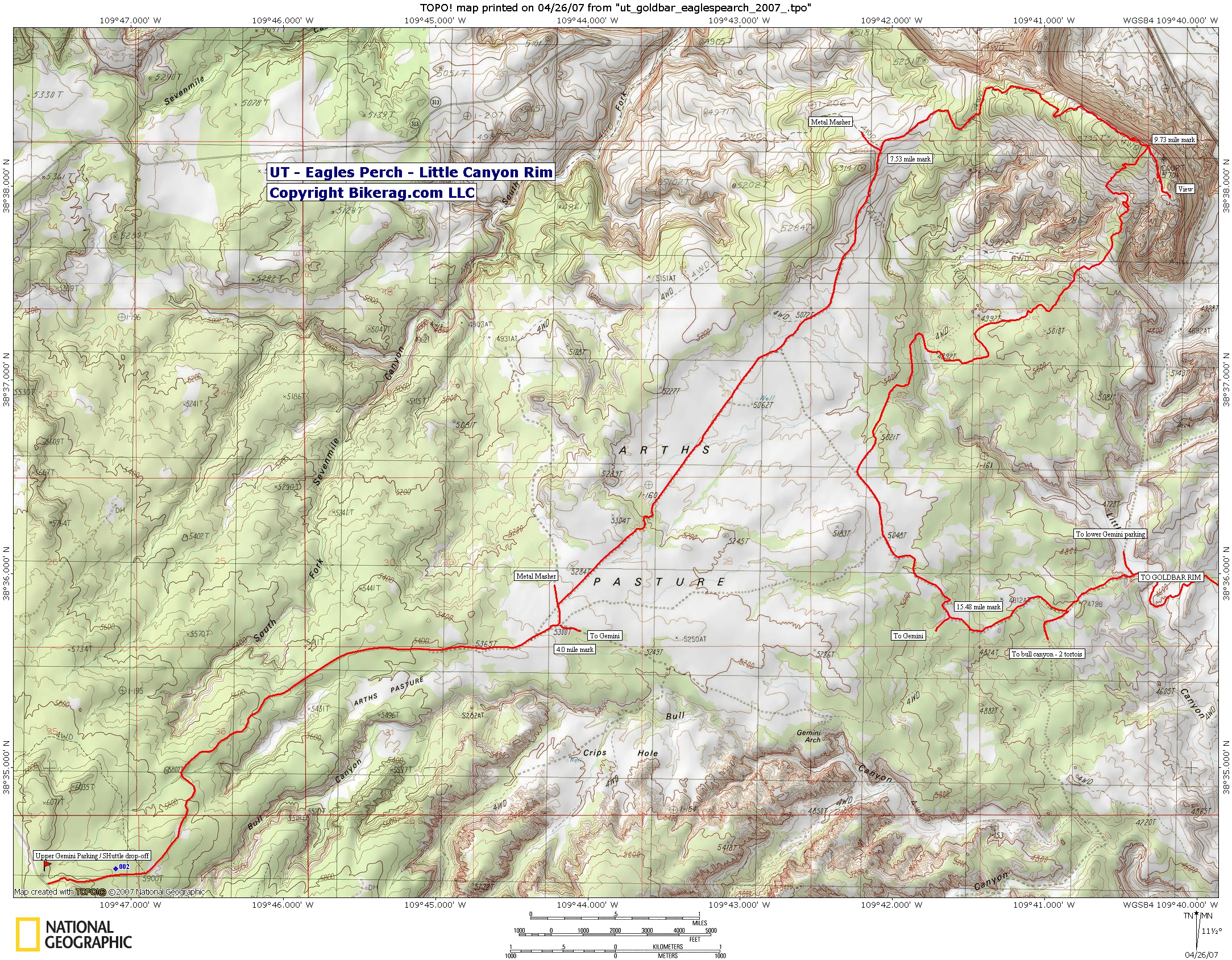
metal masher intersection?? Route from Upper Gemini - Route finding is a little tricky, I suggest you carry one of the detailed moab maps of this area, in addition to bikerag topo's.. From the upper gemini parking, go downhill for 4 miles on dirt road, you will see a small sign for gemini pointing right, TAKE A LEFT, travel just 50 or 100 ft and take your first right on art's pasture.. (an alternate route would be to keep going straight and follow metal masher).. At mile 7.53 you will meet up with metal masher, keep going straight, your in for a nice 2 mile gradual climb up some nice rock. At mile 9.73 note a right turn marked by blue ribbon.. You can take it now, or go straight out to eagles perch for view . Once you start following the road from blue ribbon its pretty easy to follow, white marks and lots of black skidmarks from jeeps.. Rock eventually turns back to dirt road - you will pass many side roads, at mile 15.48 you intersect with the main road that leads to Gemini bridges (if you take a right).. From here it depends what kind of ride you planned.. If you parked at the top of gemini, take a right and head back up.. To hit goldbar, rim take a left.. If your not doing this ride as the Goldbar Super Loop, I would suggest driving a car in and making it a loop. Unless you like riding lots of dirt road. If you drive in far enough, the loop can be as short as 9 miles but not sure where parking is cool. Description - The ride starts off as mello as can be, easy dirt road, not sure how sandy it is because we rode this just after a good rain.. The climb is great, very shallow grade, with some nice rock.. From the top down its awesome fun rock & dirt road with some really fun lines to surf, few drops, one really cool tunnel area.. Good use of your earned vertical.. Loops - |
||||||||||||||||||||||||||||||||||||||||||||||||||||
| Pre-ride Music: | ||||||||||||||||||||||||||||||||||||||||||||||||||||
| Total Miles: Shortest loop is 9, combined with Golbar Rim to portal 28 mile shuttle. | ||||||||||||||||||||||||||||||||||||||||||||||||||||
| Elevation Change Feet - Eagles Perch by itself is 700 or so vertical. Combined with golbar = 2800 ft. | ||||||||||||||||||||||||||||||||||||||||||||||||||||
|
||||||||||||||||||||||||||||||||||||||||||||||||||||
| Disclaimer: Caution - Use this map at your own risk. Bikerag.com and affiliates will not accept responsibility for an personal injury, property damage or trespassing while using this map. Trail users shall obey all signs, and always obtain permission from the land owner to use trails for any sporting activity. Permission to use trails should not be assumed. This map simply contains topographical information and trails that existed at one time. Trails shown maybe be missing, not accurate, closed, overgrown etc.... | ||||||||||||||||||||||||||||||||||||||||||||||||||||
| To
view larger version of map, right click on map and select View Image.
|
||||||||||||||||||||||||||||||||||||||||||||||||||||