|
|
|
|
| Trail map Link to Moon Lake Trail Map by Chriffer |
Map Legend |


|
|
|
|
| Trail map Link to Moon Lake Trail Map by Chriffer |
Map Legend |
| Moon Lake Park - Mountain Bike Trail Review with Map and Pictures | ||||||||||||||||||||||||||||||||||||||||||||||||||||
|
||||||||||||||||||||||||||||||||||||||||||||||||||||
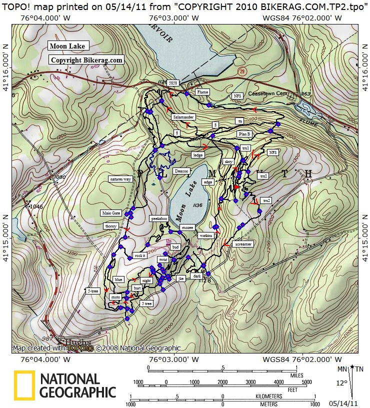
| Directions - From 81 just take route 29 west
and follow the signs. Description - This park was all about mountain biking, and hosted a nice variety of trails! Started out with some kind of plain Jane singletrack in the Thorny - 5 tree - Twister area. Stopped by the "skills area" to be thoroughly dissapointed, but hey, a teeter and a few skinnies are better than nothing. Onward to "skinny" where we found a skinny then jumped on edge where things started to get more interesting with some cool rock and switchbacks. Lots of extra trails in the edge / trex area, not sure if they are trail braids or just unmarked trails. Trex had a few cool rock lines, some sections felt, and sounded like riding on dinner plates.. We headed out towards screamer, found a pump track in the works but turned around as the trail was soft. We hit up the trials area which had a few challenging lines but looked a little abandoned. B-line to NFS, (found a little freeride trail on the left), WOW NFS rocks, sweet downhill started with some rock slabs then bench cut singletrack with some mild techs, felt like New Hampshire riding.. The Flume was pretty cool, then climbing up 5858 was GREAT, challenging trail! Deacon trials area was ok, a little ghetto, but some decent old school stuntery.. Back on nature trail that was a full day of riding and we even missed a few things. Great place to ride! As good as the trails are, you can see even more potential off trail as the terrain is very ledgy! Trails had some really good flow with a good mix of terrain to keep you entertained. Looks like there are lots of other things going on at the park too, like nature center, pool, RC airplane area etc etc.. Saw a really cool exotic blue bird at the nature center, but PMD assures me it was just a baby blue jay that looked darker because of my sunglasses. Lots of squirrels running so fast for so long I swear they are on crack. Loops - From the main parking area, we took thorny to 5 tree, left AFTER moto, then right on |
||||||||||||||||||||||||||||||||||||||||||||||||||||
| Pre-ride Music: | ||||||||||||||||||||||||||||||||||||||||||||||||||||
| Total Miles: 15 ? | ||||||||||||||||||||||||||||||||||||||||||||||||||||
| Elevation Change Feet - Our 11 mile ride was about 900 vertical | ||||||||||||||||||||||||||||||||||||||||||||||||||||
|
||||||||||||||||||||||||||||||||||||||||||||||||||||
| Disclaimer: Caution - Use this map at your own risk. Bikerag.com and affiliates will not accept responsibility for an personal injury, property damage or trespassing while using this map. Trail users shall obey all signs, and always obtain permission from the land owner to use trails for any sporting activity. Permission to use trails should not be assumed. This map simply contains topographical information and trails that existed at one time. Trails shown maybe be missing, not accurate, closed, overgrown etc.... | ||||||||||||||||||||||||||||||||||||||||||||||||||||
| To
view larger version of map, right click on map and select View Image.
|
||||||||||||||||||||||||||||||||||||||||||||||||||||