|
|
|
|
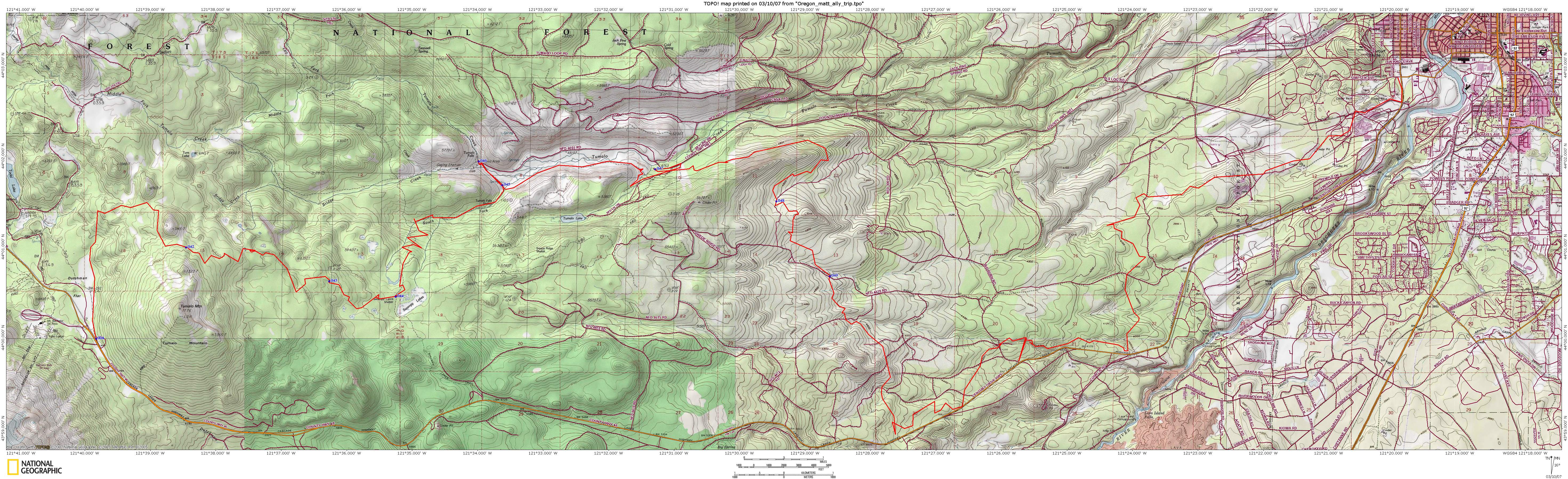
| Topo Trail Map | Map Legend |


|
Mt bachelor to Bend Epic - Mountain Bike Trail Review with Map and Pictures - Reviewed By NB & HLM |
|||||||||||||||||||||||||||||||||||||||||||||||||||||||||||||||||||||||||||||
Directions - This is a point to point ride
so you will need to have someone shuttle you up to the mountain. We had
Woody at “Cogwild” give us a shuttle ride plus a personal tour! At the
bottom, we left a car at Pine Mountain Sports, but the best place to leave a
car would be at the Phil’s Trail Trailhead. |
To get to Phil’s Trailhead: Head about 2.5 miles west on Galveston which eventually turns into Skyliners. Take first paved road on LT that has a biker icon sign. Go ½ mile down to the parking lot. To get to the beginning of the ride: Take Highway 46 (Cascades Lake Highway) out of town toward Mt Bachelor. Has you go past Mt Bachelor ski area look for the Dutchman Flat Parking Lot on your left. Park there.Description - An awesome 35 mile or so singletrack trek that consists of some climbing in the beginning (not too bad) with rewards of about 12 miles of sweeet twisty turny downhill singletrack thru beautiful old-growth forest. The rest is ups and downs of singletrack that ends in the Phil’s trail network. There are some rocky sections but far and few in-between- mostly buff singletrack. There are some fun stunts out in the middle of nowhere that are superbly built. Phil’s trails have a few as well. It gets pretty sandy as you descend in altitude so be prepared to get dirty. Loops -There are many options once you get on the Dutchman trail so I highly recommend buying the map “Mountain Biking in Central Oregon” at the Pine Mountain Sport’s Bike Shop. It’s $8 and is a topo map with a very detailed trail system. It would be very easy to get lost up there. Our point to point was as follows: Dutchman to Flagline (had fun stunts on). Left on South Fork Trail past Swampy Lakes shelter. Detour to the Tumalo Falls which was beautiful. Onto the Tumalo Creek Trail to a water stop. Skyliners Trail to Stormking which is part of the Phil’s network of trails. Onto C.O.D. which had some rocky drops to Grand Slam which had some fun stunts including a teeter-totter. Out on KBG to a “secret trail” that led us back to the Pine Mt parking lot.Pre-ride Music: |
Total Miles: |
Elevation Change Feet - |
|
Disclaimer: Caution - Use this map at your
own risk. Bikerag.com and affiliates will not accept
responsibility for an personal injury, property damage or trespassing while
using this map. Trail users shall obey all signs, and always obtain
permission from the land owner to use trails for any sporting activity.
Permission to use trails should not be assumed. This map simply
contains topographical information and trails that existed at one time.
Trails shown maybe be missing, not accurate, closed, overgrown etc.... |
To
view larger version of map, right click on map and select View Image. |
| ||||||||||||||||||||||||||||||||||||||||||||||||||||||||||||||||||||||