|
|
|
|
| Topo Trail Map | Map Legend | Bikerag Pictures |


|
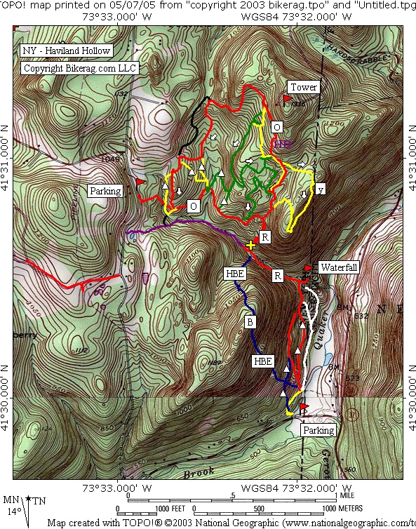
NY - Haviland Hollow - Patterson - (Walter G. Merrit County Park) Mountain Bike Trail Review with Map and Pictures |
|||||||||||||||||||||||||||||||||||||||||||||||||||||||||||||||||||||||||||||
Directions - From Hartford, take 84 west to
Danbury, route 37 north for about 8 miles and take a left on Haviland hollow
road. The road is missing a sign but there is a sign that says "TO
route 22".. If you look to your left you will see the road is in the
valley between 2 mountains. Parking is just a couple couple hundy feet
up the road on your right, cant miss it.. |
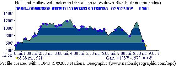
Description - Just one trip here so far but so far I like what I see.. Really have to figure out the trails to minimize hike a bike, but all in all some great riding. Lots of nice tight singletrack in here, really nice.. Some moderate tech's, nothing gonzo yet. Fantastic views and feelings of tranquility and well being along the stream, super high fen shooey factor. Some nice rock rollers here and there on and off the trail, not too many drops, some nice rock garden sections, moderate to mild, but fun.. Looking off trail this place has HUGE potential, very Ninham like. Check back soon for map update - This place is kind of like Chatfield hollow in that the direction you take the trails is very important for flow.. The Big orange fireman's memorial loop was pretty dam good taken counter clockwise.. The big orange loop is a loop with spurs, we think or Spoop, new word .. Yellow was sweet, but there are several yellows so I just told you nothing.. Go explore, have fun, my advice, Avoid the blue, not the blue triangle, but the blue - it was total hike a bike up and down.. Down was partially ride able, but pretty much a death descent for most, fun for the likes of OBD, GI, Crash Test etc... Still some hike a bike for them.. Stay away, trust me.. HBE = Hike a Bike Extremo!! Loops - From lower parking area, take buff red to red triangle singletrack, back to buff red, check out the waterfall. Follow red uphill next to stream, keep going straight past the sign for michael ciaiola trail. After you pass gate you leave the park boundary and hit some technical trail, bit muddy in parts.. Keep going up and look for your first unmarked right turn. This brings you to the yellow triangle, take a right, and another right on Orange.. Now you are on the orange loop CCW. Follow past yellow and green trails on your left, past red on your right, take SECOND right on yellow loop, look for secret roller trail on your right, sleezy, back on orange where youve already been take a right and then look for LEFT on yellow, Take to SECOND left on green just past the left on green yellow.. Follow green trail all the way back to orange, SKIP green triangle.. Back on orange where you've already been, just stay on orange all the way around for the full loop.. There are some options, you can take the yellow left to skip a hike a bike on the orange, take the unmarked right to skip the swamp.. When your at the upper parking area you can decide weather to take the red stream trail back to car or continue on orange and take the nice short technical red trail back to stream, then back to car. As you get closer to the car you can take the red trail to red triangle singletrack.. Sorry if the loop is confusing, it is what it is.. Bottom line - avoid going UP the green, take orange CCW, and the yellow loop on the right side of map, take clockwise.. Invent your own loop.. Pre-ride Music: Anything by Atmosphere |
Total Miles: 10 ish |
|
|
Disclaimer: Caution - Use this map at your
own risk. Bikerag.com and affiliates will not accept
responsibility for an personal injury, property damage or trespassing while
using this map. Trail users shall obey all signs, and always obtain
permission from the land owner to use trails for any sporting activity.
Permission to use trails should not be assumed. This map simply
contains topographical information and trails that existed at one time.
Trails shown maybe be missing, not accurate, closed, overgrown etc.... |
To
view larger version of map, right click on map and select View Image. |
| ||||||||||||||||||||||||||||||||||||||||||||||||||||||||||||||||||||||