|
|
|
|
| Ferncliff forest Trail map See also fatsinthecats.com |
Map Legend |


|
|
|
|
| Ferncliff forest Trail map See also fatsinthecats.com |
Map Legend |
| NY - Ferncliff in rhinebeck Mountain Bike Trail Review with Map and Pictures | ||||||||||||||||||||||||||||||||||||||||||||||||||||
|
||||||||||||||||||||||||||||||||||||||||||||||||||||
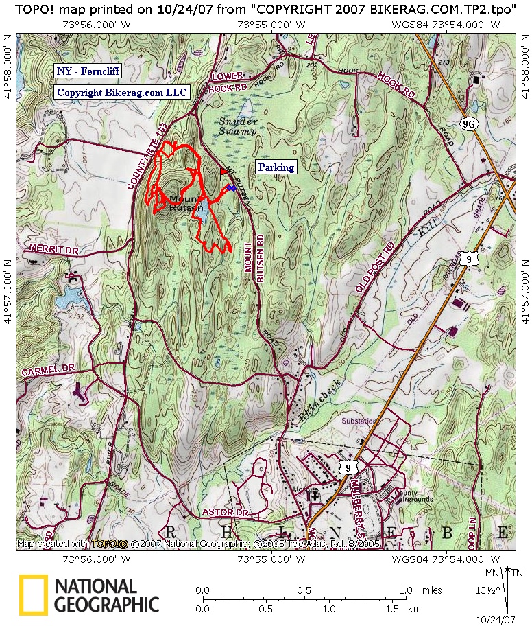
| Directions: From Kingston: Go east over the Kingston-Rhinecliff Bridge (Rt. 199) to first traffic light, Right on River Road, bear left at fork on Mount Rutsen Road, Right into parking lot at sign. From South: Take Route 9 north through Village of Rhinebeck. Left on Montgomery Street, this will turn into Mount Rutsen Road. Left into parking lot at sign. From North: Take Route 9 or 9G south towards the Town of Rhinebeck. Follow signs towards the Kingston-Rhinecliff Bridge (Rt. 199). Approx 1 mile before bridge, turn left onto River Road, bear left at fork on Mount Rutsen Road, Right into parking lot at sign. Description - Nothing too crazy here, but some decent trails if your in the area with an hour to kill.. Looks like a few people do ride here regularly. Some nice sections of singletrack, a few drops, one log ride and a jump.. Very small area - pretty crazy view from the fire tower.
|
||||||||||||||||||||||||||||||||||||||||||||||||||||
| Pre-ride Music: | ||||||||||||||||||||||||||||||||||||||||||||||||||||
| Total Miles: | ||||||||||||||||||||||||||||||||||||||||||||||||||||
| Elevation Change Feet - | ||||||||||||||||||||||||||||||||||||||||||||||||||||
|
||||||||||||||||||||||||||||||||||||||||||||||||||||
| Disclaimer: Caution - Use this map at your own risk. Bikerag.com and affiliates will not accept responsibility for an personal injury, property damage or trespassing while using this map. Trail users shall obey all signs, and always obtain permission from the land owner to use trails for any sporting activity. Permission to use trails should not be assumed. This map simply contains topographical information and trails that existed at one time. Trails shown maybe be missing, not accurate, closed, overgrown etc.... | ||||||||||||||||||||||||||||||||||||||||||||||||||||
| To
view larger version of map, right click on map and select View Image.
|
||||||||||||||||||||||||||||||||||||||||||||||||||||