|
|
|
|
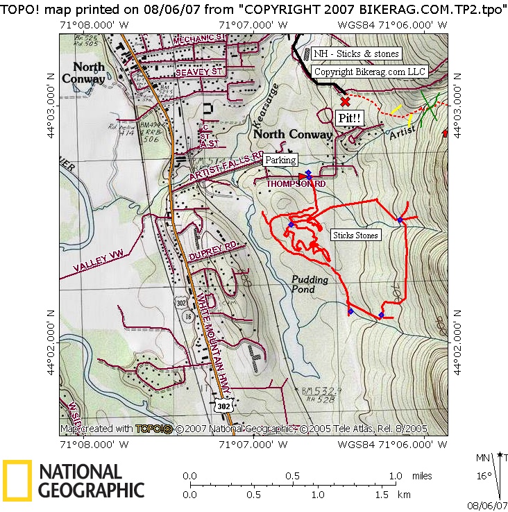
| Sticks and Stones Trail Map | Map Legend |


|
Sticks and Stones - North conway, NH - Mountain Bike Trail Review with Map and Pictures |
||||||||||||||||||||||||||||||||||||||||||||||||||||
|
||||||||||||||||||||||||||||||||||||||||||||||||||||
| Directions - Description - This is a very cool but very short singletrack loop in north conway. The trail itself is fun and non-technical but there are many beginner / intermediate rock lines right on the trail that are very well made.. Nothing bigger than a 2.5 foot drop, but all fun funny and fun. When done with sticks and stones go up and find the other trail I have on the map, from the parking area, head out under power lines, veer left (do not head towards boulders on right) and follow trail uphill till the trail splits look for faint right that is labeled "trail" with bike symbol.. Pretty dam nice section. Loops - |
||||||||||||||||||||||||||||||||||||||||||||||||||||
| Pre-ride Music: | ||||||||||||||||||||||||||||||||||||||||||||||||||||
| Total Miles: Not many, maybe 4.5 if you do S & S + the sidestep trail. | ||||||||||||||||||||||||||||||||||||||||||||||||||||
| Elevation Change Feet - | ||||||||||||||||||||||||||||||||||||||||||||||||||||
|
||||||||||||||||||||||||||||||||||||||||||||||||||||
| Disclaimer: Caution - Use this map at your own risk. Bikerag.com and affiliates will not accept responsibility for an personal injury, property damage or trespassing while using this map. Trail users shall obey all signs, and always obtain permission from the land owner to use trails for any sporting activity. Permission to use trails should not be assumed. This map simply contains topographical information and trails that existed at one time. Trails shown maybe be missing, not accurate, closed, overgrown etc.... | ||||||||||||||||||||||||||||||||||||||||||||||||||||
| To
view larger version of map, right click on map and select View Image.
|
||||||||||||||||||||||||||||||||||||||||||||||||||||