|
|
|
|
| Topo Trail Map | Map Legend | Bikerag Pictures |
|
NH - Red Tail Trail - Peaked Mtn - Mountain Bike Trail Review with Map and Pictures |
|||||||||||||||||||||||||||||||||||||||||||||||||||||||||||||||||||||||||||||
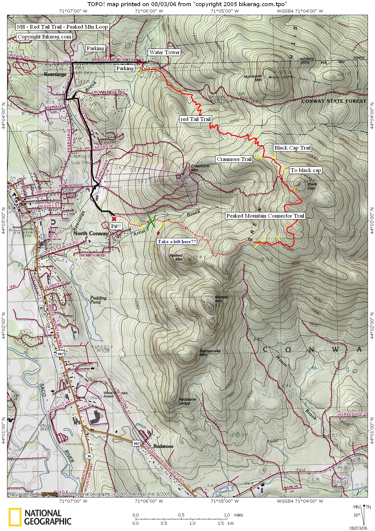
Directions - From I-93, take Rt 112 (kancamagus
highway or crankamangus to the roadies you will encounter), to left turn on
Bear Notch road,, follow all the way to 302 in Bartlett, take right 302
east, follow past Attitash, then past 16, look for Hurricane Mountain Road
on your left, take that left, follow 1.82 miles and park on right, only room
for 3 cars or so, or you can park at the earlier lot about .25 miles back
and ride up the road.. From the 1.82 mile parking spot on right, you just
ride your bike up the road 50 feet, and take a right onto dirt road, step
over wire gate, continue up to water tower, bear left uphill after tower, as
you enter woods you will see sign for red tail trail.. Good luck.. You
will have an intimate relationship with granny for the next hour or so.. |
Description - This was the best ride I've found in central NH.. The pain, the agony, the technicalities, the adventure, I was lovin it.. Red Tail most people do shuttle runs down, Climbing up wasn't so bad though, its all very rideable, somewhat technical in spots but mainly climbing through rooty, 1.5 track with some rocks.. As you go up, the trail crosses some wasteland areas which at the top give you a killer view.. Once at the top you are spent, and relieved that there is no more climbing, BUT there is!! Take a left, Climb some cool single track slick rock, then your next right (yellow and pink rock marker) and next right (to avoid climbing Black Cap) then right to Peaked Mountain connector (see sign), your still climbing!! Finally you will hit some sweet remote trail that is so bizzare, I was wondering if it was a trail, but it was, really cool rock, to ravine single with some fun lines.. Couple hike a bikes but minor.. See map for the few rights and lefts you take but the main right we took to complete the loop went like this, the trail merged with another from the right, then almost immediately there was a Y in the trail by an orange snow fence!! Take that right, then keep going right all the way to the bottom.. SOme wicked fun DHIng!! At the bottom be careful, at the end of the trail, you may see what LOOKS LIKE a nice 4 foot jump, I almost hit it blindly but did a nice brake check before I skidded off the edge - it was a 15 foot PIT on the other side.. Anyway, to get home, you will see a dirt road on the right side of the pit, just walk over there, take a left on the road and follow back to Cranmore Mtn. base lodge, then take road back to the car.. Update 2006 - Rob from White mountains Nemba clued me into a key turn I missed.. The last right turn I took on the DH was wrong.. Ill try and update the map, I hear I missed the BEST part of the Downhill!!! Might be a log ride at the top of red tail TOO as part of the white mountains log ride initiative.. Pre-ride Music: |
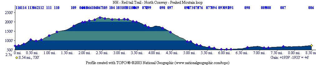
Total Miles: 20++ |
Elevation Change Feet - Elevation
Profile
|
|
Disclaimer: Caution - Use this map at your
own risk. Bikerag.com and affiliates will not accept
responsibility for an personal injury, property damage or trespassing while
using this map. Trail users shall obey all signs, and always obtain
permission from the land owner to use trails for any sporting activity.
Permission to use trails should not be assumed. This map simply
contains topographical information and trails that existed at one time.
Trails shown maybe be missing, not accurate, closed, overgrown etc.... |
To
view larger version of map, right click on map and select View Image. |
| ||||||||||||||||||||||||||||||||||||||||||||||||||||||||||||||||||||||