|
|
|
|
| Topo Trail Map | Map Legend | Pictures |
|
NH - Henniker Woods - Mountain Bike Trail Review with Map and Pictures |
||||||||||||||||||||||||||||||||||||||||||||||||||||
Thanks Crash & Burn |
||||||||||||||||||||||||||||||||||||||||||||||||||||
| Directions - In NH take Rte 101 east or
West to Rte 114 North, follow this a looong way until Rte 114 goes over a
bridge into the center of Henniker, take first right after the bridge onto
Old Rte 9 and 202. Follow for 0.6 miles and parking areas are on right and
left. Or take 93 North to Concord, to 89 North to Exit 5 for Rte 9 and 202
west, follow 5 miles to Old Rte 9 and 202 on left, 1 mile to parking on left
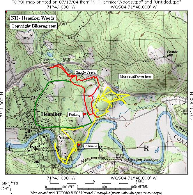
or right. Update 2007 - Checked this place out real quick.. The telephone poles in the parking area were fun, we did find some cool singletrack, but not too much of it.. Found one rock up and down, and one off camber rock jump.. Tried to find the trail by the river but it seemed totally overgrown?? So just left.. Check with the local bike shop before you go. Ok for a local ride in any case, I wouldnt go too far out of your way. Description - This local riding spot is just west of Concord. I rode it solo so didn’t have much guidance, but was able to find a pretty good network of trails for mainly intermediate and beginner levels. Oh, and there were 2 good jumps right in a row that are labeled on the map. Also a couple manmade stunts. The singletrack I rode was moderate but I hear there is much more to ride on the north side of rte 9 and 202. There is a bike shop in the center of town (it’s a small town) that can give you some good trail info and maybe a tour. |
||||||||||||||||||||||||||||||||||||||||||||||||||||
| Pre-ride Music: | ||||||||||||||||||||||||||||||||||||||||||||||||||||
| Total Miles: | ||||||||||||||||||||||||||||||||||||||||||||||||||||
| Elevation Change Feet - Elevation Profile | ||||||||||||||||||||||||||||||||||||||||||||||||||||
|
||||||||||||||||||||||||||||||||||||||||||||||||||||
| Disclaimer: Caution - Use this map at your own risk. Bikerag.com and affiliates will not accept responsibility for an personal injury, property damage or trespassing while using this map. Trail users shall obey all signs, and always obtain permission from the land owner to use trails for any sporting activity. Permission to use trails should not be assumed. This map simply contains topographical information and trails that existed at one time. Trails shown maybe be missing, not accurate, closed, overgrown etc.... | ||||||||||||||||||||||||||||||||||||||||||||||||||||
| To
view larger version of map, right click on map and select View Image.
|
||||||||||||||||||||||||||||||||||||||||||||||||||||