|
|
|
|
| Topo Trail Map | Map Legend | Bikerag Pictures |


|
NH - Greeley Ponds - East Pond Loop - EPIC - Mountain Bike Trail Review with Map and Pictures |
|||||||||||||||||||||||||||||||||||||||||||||||||||||||||||||||||||||||||||||
Directions - from I-93N, take exit 28 -
Campton-Thornton-Waterville Valley. Head east on Route 49 to Waterville
Valley. Once at WV take left onto Tripoli Road. After 1 mile
bear right at Y intersection and follow signs to Livermore road trailhead
and park.. - for alternate loop you could park at East Pond trailhead off
the Kancamagus Hwy (NH 112). |
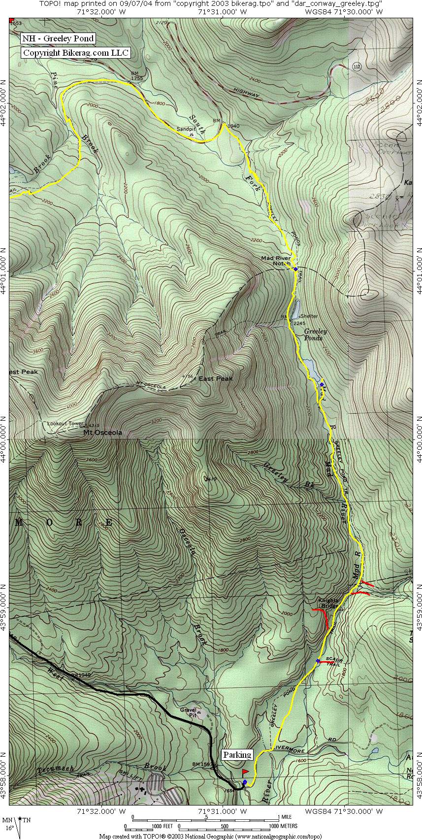
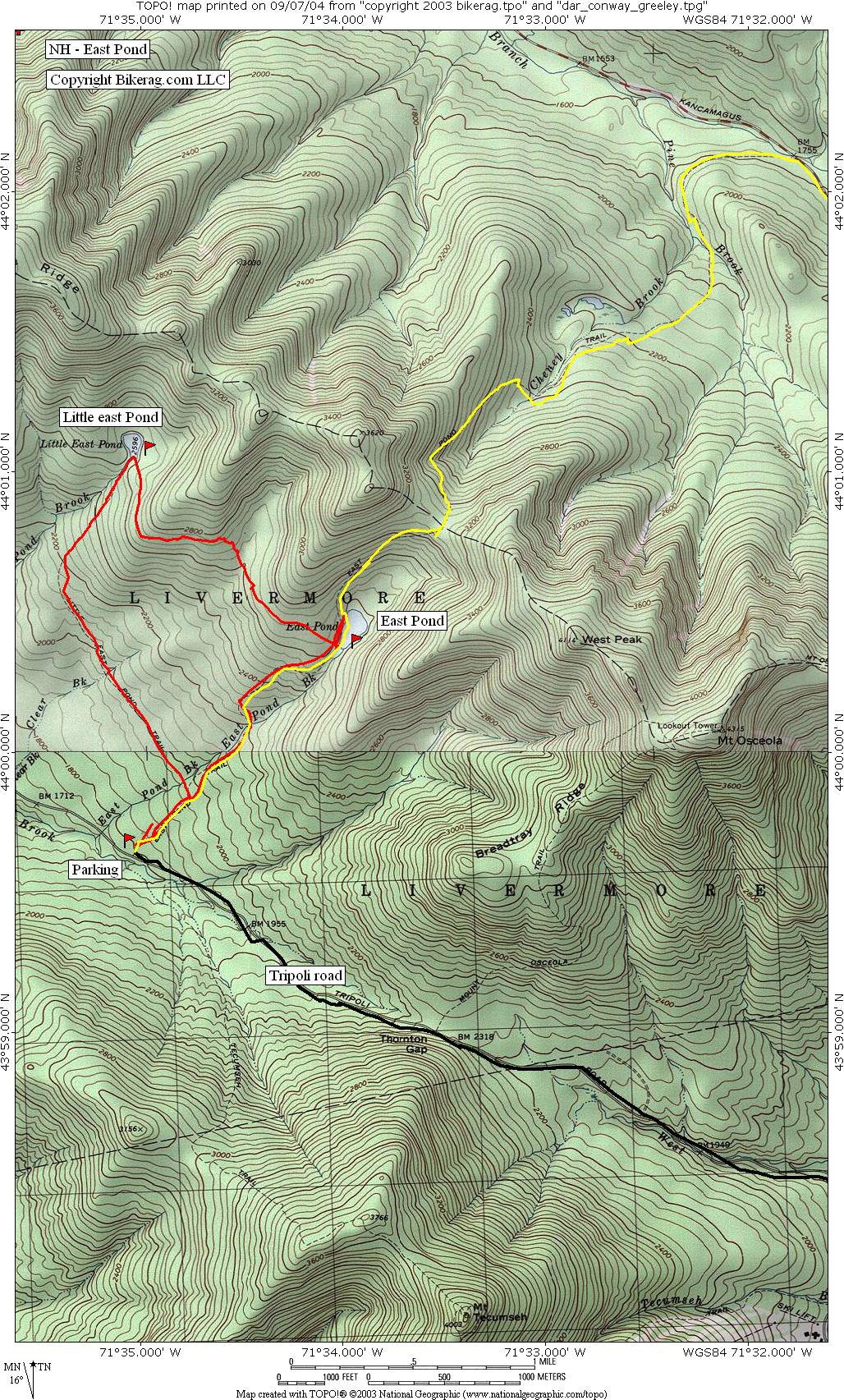
Description - warning some streams may be Impassable after rain!!! Epic ride..not for the timid.. From Livermore Road parking area take Livermore Road to Greeley Ponds Trail (about .5 miles). Starting on livermore road the trail is as wide and buff and flat as you can get.. Left on greeley ponds the trail starts harmless enough on semi rocky double, eventually it follows stream and turns narrower and rooty.. Super rooty in parts.. Couple nice rock sections, several trails can be seen on right and left, well marked.. Look for greeley pond HIKING trail and take left to avoid the 50 foot wet hike a bike we did.. Around second pond trail gets real hairy, minor hike a bike.. Onward flat then downhill, some great sections, rooty rocky etc.. We took the hiking trail all the way to 112 or the Kank, you may want to try the left on greeley pond XC trail marked with blue I believe (we'll scope it out next time we're there).. The hiking trail had quite a bit of hike a bike, but some super nice technical features, technical rocky rooty ups and downs, many planks to ride.. One section was like 300 feet of disjointed log rides - super fun.. PMD was on a mission, finally commited and cleaned the whole thing.. Towards the bottom of the greeley ponds hiking trail it gets a little hike a bikey, but still awesome stuff in between.. Again, might want to try the XC trail.. Ok be nice to the hikers and ride on to get to the Kank (NH 112), take a left, and go down the road for tad looking for East Pond trailhead on left.. up East Pond starts pretty nice, some techs here and there, middle ring stuff, then its gets progressively steeper as you go and more rocky.. One major portage over Pine Brook.. impassible after rain I assume.. Onward the trail gets rocky, technical, not for the timid.. For PMD and me it was perfect, as steep and technical as you can ride with a relentless tenacity that I have seldom seen... You'll hike your bike for 100 feet or so, and from time to time.. You keep looking up seeing endless rocky singletrack wondering if it will ever end.. Your legs and lungs will hurt but keep moving because once you reach the top it's a sweet DH to East Pond, past east pond and all the way to Tripoli Road.. If your looking for more epic add in the little east pond loop (see review. We passed the trail head on our right).. Some good moves all the way down. Left on Tripoli Road, uphill for a tad, a long tad, on dirt road, then as the road crests it turns to pavement and all downhill to the car.. Pre-ride Music: Rustic Root -
'Ecstasy' |
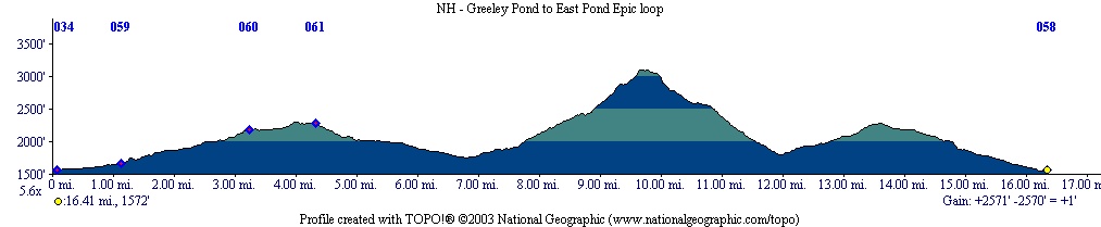
Total Miles: our loop 16.7
|
Elevation Change Feet - 2500 ft
|
|
|
Disclaimer: Caution - Use this map at your own risk. Bikerag.com and affiliates will not accept responsibility for an personal injury, property damage or trespassing while using this map. Trail users shall obey all signs, and always obtain permission from the land owner to use trails for any sporting activity. Permission to use trails should not be assumed. This map simply contains topographical information and trails that existed at one time. Trails shown maybe be missing, not accurate, closed, overgrown etc.... To
view larger version of map, right click on map and select View Image. |
| ||||||||||||||||||||||||||||||||||||||||||||||||||||||||||||||||||||||