|
|
|
|
| Topo Fox Forest Trail Map | Map Legend | Bikerag Pictures |


|
NH - Fox Forest - Mountain Bike Trail Review with Map and Pictures |
|||||||||||||||||||||||||||||||||||||||||||||||||||||||||||||||||||||||||||||
Directions - From route 9 in Hillsborough just
follow signs for Fox Forest. Once on center street, look for fox
headquarters on your right and park. Grab a map at the Kiosk. |
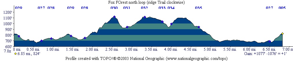
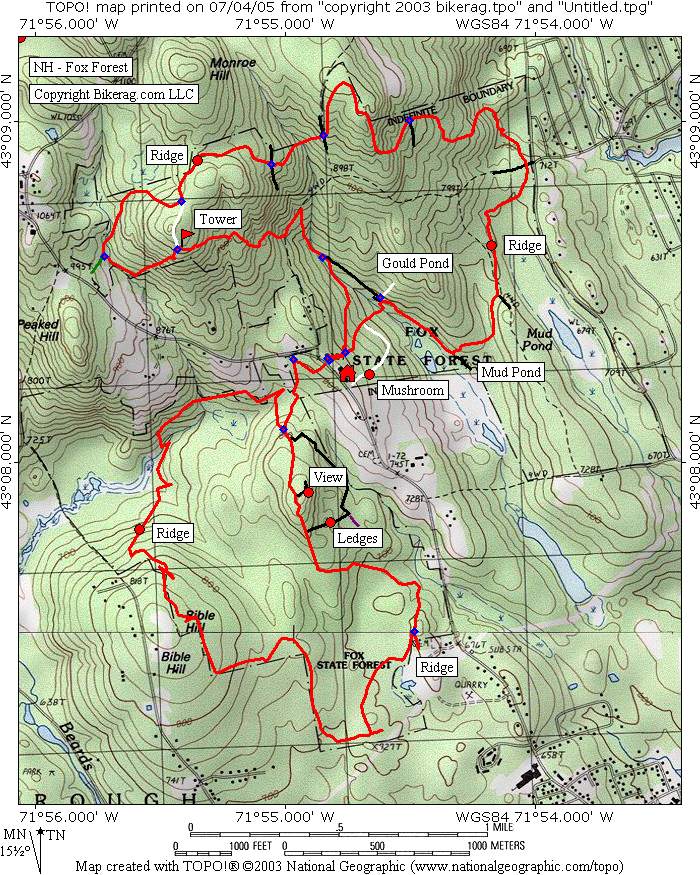
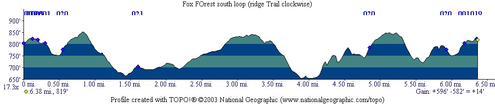
Description - There are 2 riding areas separated by center road here (North and south). All trails were well signed, but the place does need some TLC. Doesnt seem to get much use. South side - (ridge trail taken clockwise) Mix of fire roads, doubletrack and singletrack. Some sweet rocky singletrack. Rocky double had some really flowy lines, mini air but fun. One section was pretty much wastelands due to logging but went by fast.. Some really cool fern lined rocky singletrack in the middle, but watch out for one nasty crappy muddy section on the ridge trail.. You might be able to avoid it by detouring from ridge - Right on barred owl trail, left on white cross, right back on ridge. Let me know how that works out. South side was pretty flat. North Side - (Ridge trail taken Clockwise) - Little different from the south side, much more elevation, more technical. Some hike a bike required for a couple steep hills and about 10-20 portages due to mudd or un-rideable sections.. If your not an expert rider, I wouldnt attempt the north side. Some freakin awesome lines but pretty abandoned.. Does anyone ride here?? This place needs some TLC, could be so much better. Maybe IMBA trail care crew should pay a visit.. This place has some heritage to it also.. Might want to check out the 400 year old black gum trees on the white cross trail, or the many species in the mud pond area. Loops - Ridge Trail Loop plus some side trail adventures. Pre-ride Music: Charlie daniels Whooly swamp. |
Total Miles: 20 +/- |
|
|
Disclaimer: Caution - Use this map at your
own risk. Bikerag.com and affiliates will not accept
responsibility for an personal injury, property damage or trespassing while
using this map. Trail users shall obey all signs, and always obtain
permission from the land owner to use trails for any sporting activity.
Permission to use trails should not be assumed. This map simply
contains topographical information and trails that existed at one time.
Trails shown maybe be missing, not accurate, closed, overgrown etc.... |
To
view larger version of map, right click on map and select View Image. |
| ||||||||||||||||||||||||||||||||||||||||||||||||||||||||||||||||||||||