|
|
|
|
| Topo Trail Map | Map Legend | Bikearg Pictures |
|
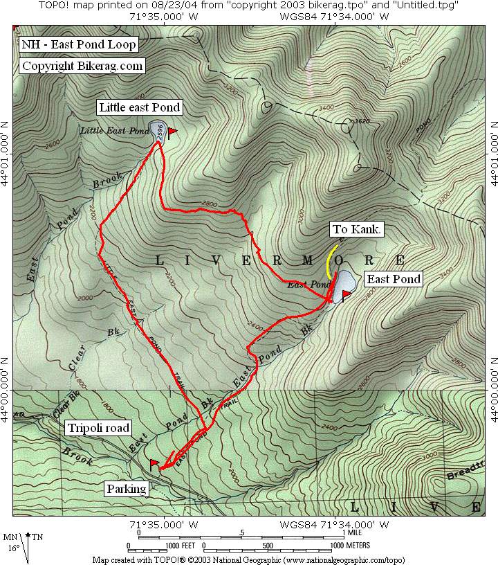
NH - East Pond - Little East Pond Loop- Mountain Bike Trail Review with Map and Pictures |
||||||||||||||||||||||||||||||||||||||||||||||||||||||||||||||||||||||||||||||
Directions - 93 north to exit 31, Tripoli
Road, take right on Tripoli and follow for 5.3 miles, take left into parking
area, pay 3.00 fee.. |
Description - What an awesome killer 5 mile loop, lots of bang for your 3 bucks.. I did the loop clockwise, but I wonder how it would be CCW?? Ill warn you, regardless of which way you go, without mad skillz, you will hate this place.. Ill describe the loop I took and you decide if its for you.. From the parking area, go up the fire road about .25 miles, turns to singletrack, take left on little east pond trail.. Trail is flat for a while, some ditches to traverse, couple skinnys, couple hike a bikes due to stream crossing or ditches.. Then the climb, pretty relentless, as steep and technical as you can climb, but just for 1000 feet (VERICAL), I made most of the climb, dabbing here and there, only a couple of carries, passed some girls hiking, they liked my "ride like a girl" stickers.. Just some killer technical uphilling so far, I was proud to only punkinseed my testicles once.. At the top - phew - little east pond, ohhh ahh, take a right and continue on.. Some uphill then up and down to east pond.. This section was killer.. Super Dupa skillz, but most doable, I was twiggling, and wiggling, ratcheting and backpedaling, sliding on roots, nose wheeleiing and hopping the back wheel and even with all that effort I must have dabbed 25 times, plus a handfull of carries.. But it wasn't annoying, it was fun, you wanted more.. Plus it was wet so imagine dryer would be better (in this case).. Some really short flowing DH sections, oh man, it was the best.. ONce at east pond you will see many beached whales and mountain view.. Take the wide trail down, be careful of water bars, you can gap some of them, but many will require a nice moderate speed manual.. My hands were sore..and not just because this trail made me sooo excited.. Some air time.. Towards the bottom a nice single track rock garden that reminds me of the best section at pachaug, by the stream... A killer short, brutal ride.. Pre-ride Music: |
Total Miles: 5 plus |
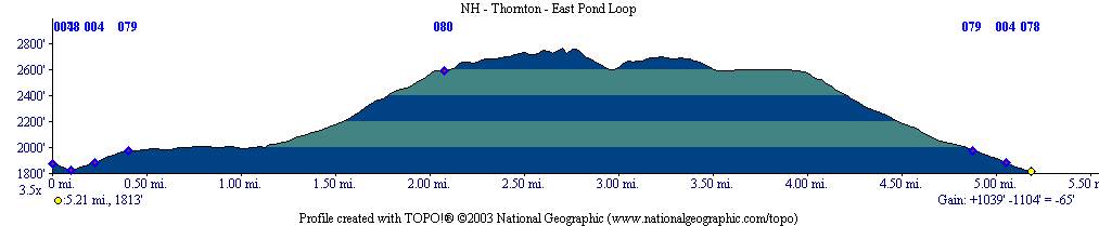
Elevation Change Feet - Elevation
Profile
|
 |
|
Disclaimer: Caution - Use this map at your
own risk. Bikerag.com and affiliates will not accept
responsibility for an personal injury, property damage or trespassing while
using this map. Trail users shall obey all signs, and always obtain
permission from the land owner to use trails for any sporting activity.
Permission to use trails should not be assumed. This map simply
contains topographical information and trails that existed at one time.
Trails shown maybe be missing, not accurate, closed, overgrown etc.... |
To view
larger version of map, right click on map and select View Image. |
| ||||||||||||||||||||||||||||||||||||||||||||||||||||||||||||||||||||||