| Directions - (bring a map to be safe- I've
never been here!!) From Roxbury Center take walnut street west, as it
crosses the highway clear your odo, this is route 202A, take 202 a WEST for
3.09 miles, then take right (fork) (not sure what road), 1.8 miles
intersection, straight, .1 miles park on right by reservoir, room for 3
cars. GPS coordinates for parking - GPS
Data Format DegMin NAD83 ElevFeet Local-Time
001,43,19.047,-71,04.950,482,09/01/2004,08:51:20, -
Description - Thought I'd make a dent in the hit
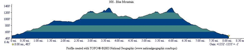
list with a review of Blue Job Mountain. Did the ride a couple months back.
Overall it's not a bad ride (probably give it a 3.5 out of 5). I actually
did the ride in the book "Mountain Bike America, New Hampshire Maine" by Bob
Fitzhenry. His route isn't that great. Found out doing anything west of 1st
Crown Point road was a waste of time. It was basically consisted of biking
on road, wide jeep track, and little used wide fireroads. Very boring.
Ok, on to the goods. This is a route that I road and which I would ride
again the next time there (maybe do a little more exploring to the north and
east). Basically consists of a 3 mile out and back with two loops at the
end, which totals aprox 8 miles of nice single track (most of it technical).
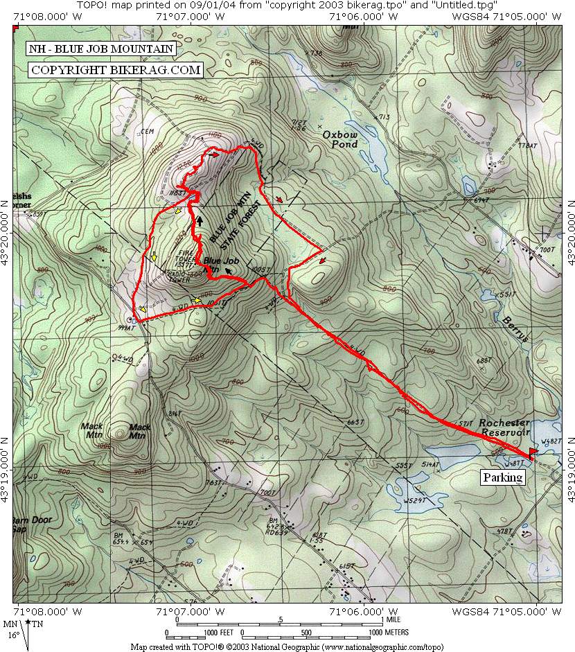
Park on Sheepboro Road next to a large pond on the left (fits about 3 cars).
First part of the ride consists of a 1.5 mile segment up this road. The
gravel road quickly turns in a very nice wide technical singletrack that
goes up and up (all rideable). It's a nice moderately challenging technical
climb with lots of rocks, sheetrock, roots and some nice drop offs (1,2 ft)
for the return ride. A little ways past the red house you come to a T in the
trail. Take a left and go for a short distance (wide double track which has
a slight downhill). Looking right you come upon a trail that starts up the
mountain again, it's kinda hard to spot so keep a good lookout. Take this up
and continue climbing. This trail is basically some steep single track (some
hike-a- bike, especially toward the top). Once at the top, a visit to the
fire tower is in order (great views). Once rested it's on to the descent
down the north side. Great technical descent to a nice pond at the bottom!
Once around the pond veer to the left to start the first loop. A shallow
descent on twisting, some tight single track (some of the trail is new).
This brings you out to 1st Crown point road (there is also a parking area
here). There is another map of the trails in the area. You can continue on
the trail in a eastern direction or go southeast for about 50 yards and take
the trail to the left. This .5 mile trail is basically a nice technical
climb on wide single track on the first portion follow by smooth doubletrack
on the second half. Again you go up the trail that got you to the top the
first time, great descent down the north side.and around the pond. This time
take a right up the hill north of Blue Job. On top is nice views and lots of
slickrock. Next go northeast and let the descent begin! This trail is
descent single to doubletrack for about a 1.5 miles . This leads back to the
Sheepboro road trail that was climbed in the beginning. It's a great fast
and technical descent. Overall not a bad ride.
NEW -
GPS route
Text File - Comma
delimited |
| Disclaimer: Caution - Use this map at your
own risk. Bikerag.com and affiliates will not accept
responsibility for an personal injury, property damage or trespassing while
using this map. Trail users shall obey all signs, and always obtain
permission from the land owner to use trails for any sporting activity.
Permission to use trails should not be assumed. This map simply
contains topographical information and trails that existed at one time.
Trails shown maybe be missing, not accurate, closed, overgrown etc.... |