|
|
|
|
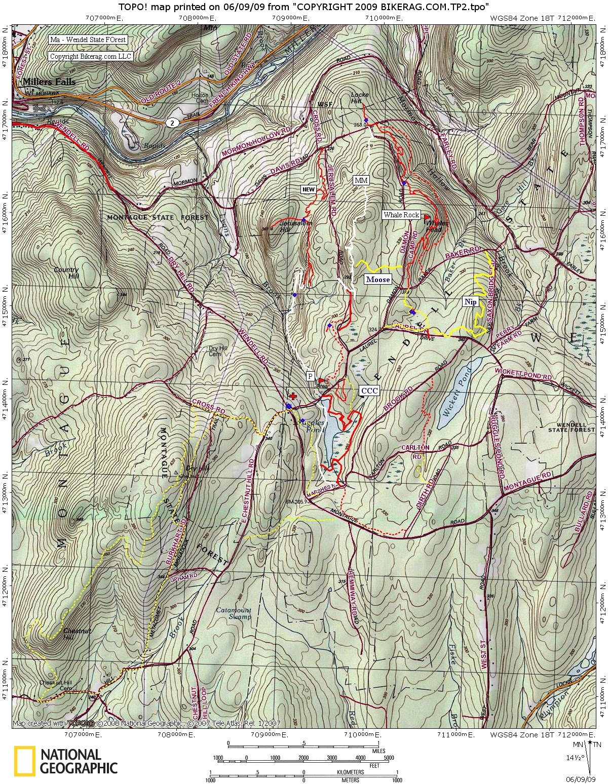
| Topo Trail Map | Map Legend |


|
MA - Wendell state forest - Mountain Bike Trail Review with Map and Pictures - Preliminary |
|||||||||||||||||||||||||||||||||||||||||||||||||||||||||||||||||||||||||||||
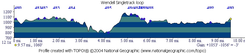
Update 2009: Ended up riding just a day after
the new trail went in. Nice long trail that parallels Jerusalem Rd,
very soft but im sure it will firm up after a few months of riding.
TO get there take the white tornado trail till you hit the road, take a
right. Climb up the hill and take your SECOND left. (First left
is a Hike a bike). Second left may be a little bit hidden.
Always new stuff to check out at Wendell - I still need to check out the
loop across the street shown dashed yellow on the map.
|
Directions - From 91 take route 2 east, right on 63 south to millers falls. Once in millers falls look for signs to wendell, KEEP YOUR EYES PEELED.. Basically look up the hill from the center of town you will see a bridge, drive over the bridge and stay left. 1.09 miles bear right , 1.82 miles you will see park office, park there if the gate is closed, or if its open, drive in and pay fee..
Description - Nemba has done some great work in here with some really nice technical singletrack. A good example on how your membership dollars help the mtb community - Thanks NEMBA.. Anyway - what we found was a mix of fire roads, buff singletrack and technical singletrack. The new singletrack has some nice flow and routed over every rock in the area, almost metavomit style.. No stunts, but nice natural rock features including drops from 3-5 feet.. Some amazing rock work to keep your flow. Loop I outlined includes a sweet section of the m&m trail with some nice slab rock and views.. Trail around the lake was nice buff singletrack but im not positive that bikes are allowed. It was not labeled foot path like some sections of the M&M are.. Loops - First singletrack starts at the CROTCH of damon camp and wicket. Short trail, once its back on road, take left, and 50 feet, another left.. First intersection go LEFT.. Then just stay on the trail straight - at whale rock stay RIGHT after you check out whale rock.. Once you get to the doubletrack go left up hill, follow white dots, right on white dot single, UPHILL with some sweet leg aching lines to the top.. ONce on top, some good embedded slab rock.. Eventually the white drops back down the fire road, go left back home.. Pre-ride Music: |
Total Miles: LOTS |
|
|
Disclaimer: Caution - Use this map at your
own risk. Bikerag.com and affiliates will not accept
responsibility for an personal injury, property damage or trespassing while
using this map. Trail users shall obey all signs, and always obtain
permission from the land owner to use trails for any sporting activity.
Permission to use trails should not be assumed. This map simply
contains topographical information and trails that existed at one time.
Trails shown maybe be missing, not accurate, closed, overgrown etc.... |
To
view larger version of map, right click on map and select View Image. |
| ||||||||||||||||||||||||||||||||||||||||||||||||||||||||||||||||||||||