|
|
|
|
| Trail map link | Map Legend |


| Russell Mill Pond - Mountain Bike Trail Review with Map and Pictures | ||||||||||||||||||||||||||||||||||||||||||||||||||||
|
||||||||||||||||||||||||||||||||||||||||||||||||||||
| Directions -
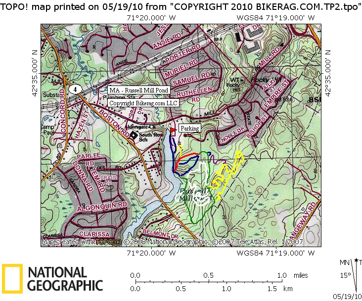
130 Mill Rd, Chelmsford Description - Finally got a chance to check this place out after seeing some reports from G Remf on crankfire. I really didnt have super high expectations, figured some buff singletrack with a few log rides. The singletrack was amazing, laid out perfectly for flow in either direction and routed over or near any rock in the area. Not a ton of rocks, but a few notable natural rock features like the "BFR" roller that was a killer up. Or the Knife Edge "Nose Roller" (see pic), PMD thinks it looks like darth vader.. A few 2 footers and a few natural jumps too. One nice 5 footer seemed to have a pile of dirt dropped right in the middle of the landing (look before you leap). Link this ride with Great Brook Farm for more miles too! Not tons of miles, but a good rip for an hour or 2 if your playing on stuff. Log rides were super easy but still fun. Pump track was great, even flowed good on the monster wheelbase nomad. I would not make a special trip from too far away since the miles are low, but if your ever driving by on 495, check it out.. Hats off to the trail builders / Maintainers - A+ Job.. Keep building...
Loops - Ride it all.. Seems most trails worked both ways. I managed to ride in the direction of the major trail features. I took White counter clockwise, Yellow Clockwise.. |
||||||||||||||||||||||||||||||||||||||||||||||||||||
| Pre-ride Music: | ||||||||||||||||||||||||||||||||||||||||||||||||||||
| Total Miles: Maybe 6 or 7? | ||||||||||||||||||||||||||||||||||||||||||||||||||||
| Elevation Change Feet - Its pretty flat, My legs felt better at the END Of the ride.. | ||||||||||||||||||||||||||||||||||||||||||||||||||||
|
||||||||||||||||||||||||||||||||||||||||||||||||||||
| Disclaimer: Caution - Use this map at your own risk. Bikerag.com and affiliates will not accept responsibility for an personal injury, property damage or trespassing while using this map. Trail users shall obey all signs, and always obtain permission from the land owner to use trails for any sporting activity. Permission to use trails should not be assumed. This map simply contains topographical information and trails that existed at one time. Trails shown maybe be missing, not accurate, closed, overgrown etc.... | ||||||||||||||||||||||||||||||||||||||||||||||||||||
| To
view larger version of map, right click on map and select View Image.
|
||||||||||||||||||||||||||||||||||||||||||||||||||||


