|
|
|
|
| Topo Trail Map | Map Legend | Pictures |
|
MA - Hodges Village Dam - Mountain Bike Trail Review with Map and Pictures |
||||||||||||||||||||||||||||||||||||||||||||||||||||
Reviewed by Crash N Burn - thanks man! |
||||||||||||||||||||||||||||||||||||||||||||||||||||
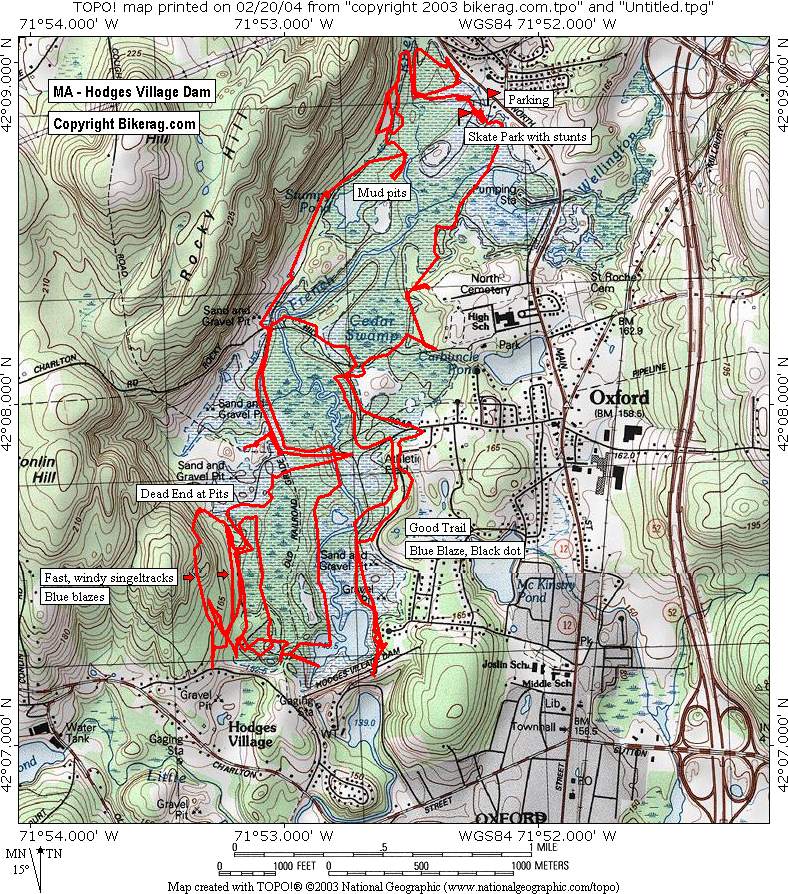
| Directions - Mass Pike to Exit 10, Rte 52 South
to exit 5, right off exit onto Depot St., go 0.6 miles and take right on
North Rd., short distance to parking area for town fields and skate park. Description - Just off the parking area is a mini skate park and one 3 foot wall drop, which are the only sort of stunts or technicalities to be found. I’m not even sure if the skate park is legal, but there are some small ramps, spines and jumps to play on. There are various types of riding in this area making it fun for all levels. There is single and double track, very muddy riding through the swamp areas, very dry riding through the sandpit area and a few stream crossings near the parking area. The fast, windy single-track on the south side of the park near the dam is by far the best. There are some rolling hills that give a mild workout and keep the pace high and fun. I rode 15 miles of trails but I imagine there are several more miles to the west of the dam. Basically this place is not for the extreme, technical or endurance rider, but is good to check out some different XC for a relaxing change of pace. |
||||||||||||||||||||||||||||||||||||||||||||||||||||
| Pre-ride Music: | ||||||||||||||||||||||||||||||||||||||||||||||||||||
| Total Miles: | ||||||||||||||||||||||||||||||||||||||||||||||||||||
| Elevation Change Feet - Elevation
Profile
|
||||||||||||||||||||||||||||||||||||||||||||||||||||
|
||||||||||||||||||||||||||||||||||||||||||||||||||||
| Disclaimer: Caution - Use this map at your own risk. Bikerag.com and affiliates will not accept responsibility for an personal injury, property damage or trespassing while using this map. Trail users shall obey all signs, and always obtain permission from the land owner to use trails for any sporting activity. Permission to use trails should not be assumed. This map simply contains topographical information and trails that existed at one time. Trails shown maybe be missing, not accurate, closed, overgrown etc.... | ||||||||||||||||||||||||||||||||||||||||||||||||||||
| To
view larger version of map, right click on map and select View Image.
|
||||||||||||||||||||||||||||||||||||||||||||||||||||