|
|
|
|
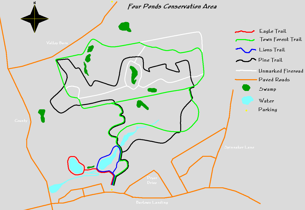
| Trail map | Map Legend |


|
Four Ponds Recreation area - Bourne Ma - Mountain Bike Trail Review with Map and Pictures
Review By JJ - Thanks for your contribution! |
||||||||||||||||||||||||||||||||||||||||||||||||||||
|
||||||||||||||||||||||||||||||||||||||||||||||||||||
| Directions -
When you reach Cape Cod, take the
Bourne Bridge, go around the rotary onto route 28 (straight
across from the bridge) continue for about a mile and turn right onto
Barlows Landing Road (before Dunkin Donuts). Continue on this road, pass
a couple of banks, Spinnaker Lane, and after the second Pryer Drive, you
will see a parking area on the right side of the street. You can also
park on Valley Bars Road by the Bourne Water District, or behind the
Weary Travelers Club off of Valley Bars Road. You can get a printed
trail map at the Town Hall across the bridge if you desire (24 Perry
Ave.).
Description - Four Ponds is named for, get this, the four bodies of water within the conservation (so creative), Shop Pond, Freeman Pond, Upper Pond, and The Basin. The entire area of this and the Bourne Town Forest (bordered by Four Ponds) is 280 acres. A really great place to ride with fun, rolling terrain and trails, which are marked pretty well. Very fun roller coaster ride in certain areas. Swooping trails over this rolling terrain make it a really enjoyable place to ride. My suggested route would be from the parking area, go into the trails for about 100 yards where there is an information board which use to have a map on it, but I’m not sure if someone decided to take it with them or what, because it is now an informationless information board. Anyway, keep going straight from the information board on to the Pine trail and ride this trail. This is the favored trial by me, but it is fun to ride any of the trails. The best part of the pine trail by far is (when heading north) the trail on the east side that is a sort of C shape crossing the town forest trail. All trails are color coated: eagle trail-red, town forest trail-green, lions trail-blue, pine trail- black. The first 100 yards into the forest is all of the trails combined when you get to the information board, the eagle trail and lions trail are to the left, town forest trail is right, and pine trail is straight. There are some nice bridges and benches, which are in place due to the acts of either the Boy Scouts, or the Lions Club. Different organizations in 2000-2002 restored the wetlands and created this trail system. There aren't usually to many people out here, mainly people walking their dogs or just walking themselves. The amout of people always depends on what time you go. Loops - |
||||||||||||||||||||||||||||||||||||||||||||||||||||
| Pre-ride Music: Shinedown - The Sound of Madness | ||||||||||||||||||||||||||||||||||||||||||||||||||||
| Total Miles: | ||||||||||||||||||||||||||||||||||||||||||||||||||||
| Elevation Change Feet - | ||||||||||||||||||||||||||||||||||||||||||||||||||||
|
||||||||||||||||||||||||||||||||||||||||||||||||||||
| Disclaimer: Caution - Use this map at your own risk. Bikerag.com and affiliates will not accept responsibility for an personal injury, property damage or trespassing while using this map. Trail users shall obey all signs, and always obtain permission from the land owner to use trails for any sporting activity. Permission to use trails should not be assumed. This map simply contains topographical information and trails that existed at one time. Trails shown maybe be missing, not accurate, closed, overgrown etc.... | ||||||||||||||||||||||||||||||||||||||||||||||||||||
| To
view larger version of map, right click on map and select View Image.
|
||||||||||||||||||||||||||||||||||||||||||||||||||||