|
CT - Hurd State Park - Mountain Bike Trail Review with Map and Pictures |
||||||||||||||||||||||||||||||||||||||||||||||||||||||||||||||||||||||||||||
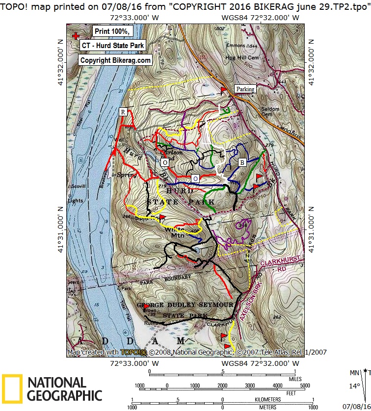
Directions - Rte 9 south to middletown, take
(rte 17 / 66) east over river. Take right on 66 east just after bridge
at light. Travel 5 miles and take right on 151 south. 2.45 miles
take hard right before light and park in dirt lot, OR take soft right and
follow the signs for the main entrance.. |
Update 2011 Hurd has had a growing # of buff singletracks pop up, but lately I see a few fun rock lines off trail developing. Nothing gonzo, but good to see. New Purple trail has been added to the map too. Update 2008 - A few new trails have been poping up over the past 2 years and have been added to map. New trails are totally XC, but there sure are some fun rocks just off trail (see pictures). Description - This is a small state park with mainly easy XC trails but some cool rock stuff 2 boot.. Its like a cross between wadsworth falls and lynn woods like that means anything to you.. Some hills, some slick rock sections that are really really cool, with awesome views.. You can adventure down to the abandoned george dudly state park, find some old stairs to ride, a perfect 2-3 foot drop, and one exerrent 7-10 foot huck with transition landing.. Although this place was pretty dam tame, it has SOOO much potential, crazy rideable rocks everywhere off trail.. Rocks are smoother than middlesex, and woods are much less dense and lacking deathly laurell trees that i have to duck under.. Pre-ride Music: Rusted
root - balls turned blue, or make that cat turned blue |
Total Miles: im gonna say 11 ish |
Elevation Change Feet - 500-1000 |
Nearest Coffee, Sushi or other food: On the way
to middletown home, I found TWO count them 2 dunkin donuts. Go
to middletown for any food you crave - Eli Cannons - bar food, Mikado -
sushi plus theres a Thai place - all on main street.. |
|
Disclaimer: Caution - Use this map at your
own risk. Bikerag.com and affiliates will not accept
responsibility for an personal injury, property damage or trespassing while
using this map. Trail users shall obey all signs, and always obtain
permission from the land owner to use trails for any sporting activity.
Permission to use trails should not be assumed. This map simply
contains topographical information and trails that existed at one time.
Trails shown maybe be missing, not accurate, closed, overgrown etc.... |
To
view larger version of map, right click on map and select View Image. |
|
| |||||||||||||||||||||||||||||||||||||||||||||||||||||||||||||||||||