|
|
|
|
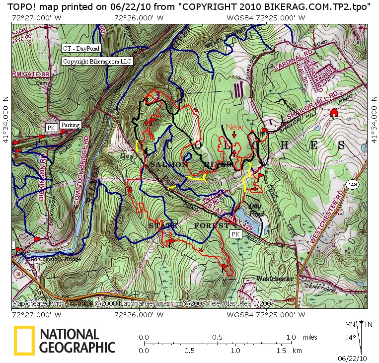
| Day Pond Trail Map | Map Legend |


|
CT - Day Pond State park - Salmon River - Mountain Bike Trail Review with Map and Pictures |
||||||||||||||||||||||||||||||||||||||||||||||||||||
|
||||||||||||||||||||||||||||||||||||||||||||||||||||
| Update 2010: Day pond is in great shape.
Some cool natural features in there. Directions - From Route 2 take 149 west for about 3 miles, look for hairpin right on Peck lane then left on daypond road. Note, there are signs for day pond state park. Description - I decided to give the day pond area of salmon river a separate review after an excellent tour the other day. Day pond area is quite the little jem for mountain biking, amazing scenery, technical singletrack with some fine features here and there for bonus smiles.. Great mix of everything, one stop shopping, several drops, several log rides (SOME HUGE, and by huge, I mean, Gi-Normouse), sweet rock slab riding and some classic new england old school technical riding.. Day pond might be the new grayville, which was thenew case, but not after tyler mill was the new case and millers pond was the new tyler mill.. PHEW.. WHAT ARE YOU DOING, get off your ass and ride here.. Oh yeah, some dam fine parking lot riding too, but watch out for snakes.. Loops - I suggest a tour although the gpx route file is dead on, there are so so so many turns.. Lots of short sections of singletrack connected with fire roads. route_xs.gpx 7.87 miles, 600 vertical |
||||||||||||||||||||||||||||||||||||||||||||||||||||
| Pre-ride Music: | ||||||||||||||||||||||||||||||||||||||||||||||||||||
| Total Miles: Typical XS loop is about 7 miles, 500 vert, but will feel like double that. If you do it right. | ||||||||||||||||||||||||||||||||||||||||||||||||||||
| Elevation Change Feet -5 hundy | ||||||||||||||||||||||||||||||||||||||||||||||||||||
|
||||||||||||||||||||||||||||||||||||||||||||||||||||
| Disclaimer: Caution - Use this map at your own risk. Bikerag.com and affiliates will not accept responsibility for an personal injury, property damage or trespassing while using this map. Trail users shall obey all signs, and always obtain permission from the land owner to use trails for any sporting activity. Permission to use trails should not be assumed. This map simply contains topographical information and trails that existed at one time. Trails shown maybe be missing, not accurate, closed, overgrown etc.... | ||||||||||||||||||||||||||||||||||||||||||||||||||||
| To
view larger version of map, right click on map and select View Image.
|
||||||||||||||||||||||||||||||||||||||||||||||||||||