|
|
|
|
| Topo Trail Map | Map Legend | Bikerag Pictures |
|
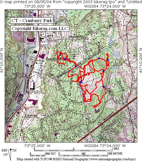
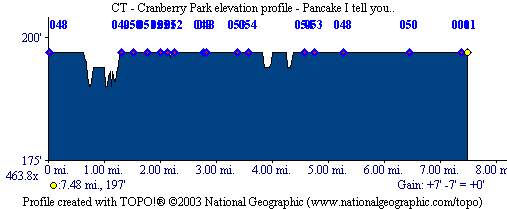
CT - Cranberry Park - Jack Rabbit Run - Mountain Bike Trail Review with Map and Pictures |
|||||||||||||||||||||||||||||||||||||||||||||||||||||||||||||||||||||||||||||
Directions - From the Merritt Parkway (Route 15)
take route 7 north for 1.62 miles and take a right on Kensett road, just
follow to end (T) go straight into park.. |
Description - Cranberry park is a very small park in Norwalk that gets a plethora of traffic on a daily basis plus a yearly race that attracts hordes of mountain bikers.. The trails show lots of wear and tear, basically - best way I can describe it is a spider web of buff double and triple track with some rocky sections and some roots.. Its OK, it doesn't totally suck, if your in the area and need to pedal, hit it to spin some miles, I managed to catch air a few times and found one or 2 cool lines, but nothing to moisten my crotch.. Loops - Just ride everything.. Pre-ride Music: |
Total Miles: 8 ish |
Elevation Change Feet -
|
|
Disclaimer: Caution - Use this map at your
own risk. Bikerag.com and affiliates will not accept
responsibility for an personal injury, property damage or trespassing while
using this map. Trail users shall obey all signs, and always obtain
permission from the land owner to use trails for any sporting activity.
Permission to use trails should not be assumed. This map simply
contains topographical information and trails that existed at one time.
Trails shown maybe be missing, not accurate, closed, overgrown etc.... |
To
view larger version of map, right click on map and select View Image. |
| ||||||||||||||||||||||||||||||||||||||||||||||||||||||||||||||||||||||